Approximate Location Map
Large Map »
Latitude: 52.9149 / 52°54'53"N
Longitude: -0.6407 / 0°38'26"W
OS Eastings: 491498
OS Northings: 336145
OS Grid: SK914361
Mapcode National: GBR DQ4.6TJ
Mapcode Global: WHGKH.4Z5Q
Plus Code: 9C4XW975+XP
Entry Name: Church of St Wulfram
Listing Date: 8 May 1950
Grade: I
Source: Historic England
Source ID: 1062501
English Heritage Legacy ID: 192904
ID on this website: 101062501
Location: St Wulfram's Church, Grantham, South Kesteven, Lincolnshire, NG31
County: Lincolnshire
District: South Kesteven
Electoral Ward/Division: Grantham St Wulfram's
Parish: Non Civil Parish
Built-Up Area: Grantham
Traditional County: Lincolnshire
Lieutenancy Area (Ceremonial County): Lincolnshire
Church of England Parish: Grantham St Wulfram
Church of England Diocese: Lincoln
Tagged with: Church building
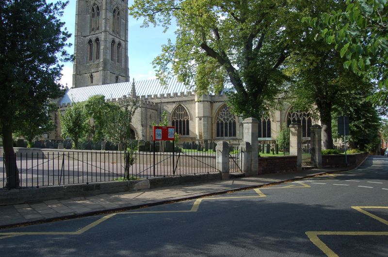
SK 9136 SW GRANTHAM
607/7/1 Church of St Wulfram
08.05.1950 I
196 x 75 feet. Probable Salisbury influence. North aisle arcades, except
for the 2 west bays, date from before 1180. North aisle rebuilt circa 1250.
1350 South aisle lengthened and Lady Chapel built, 1450 North aisle extended.
St. Katherine's Chapel added after 1496 by the Hall family, Church restored
by Sir G G Scott 1866-75. Of special interest are window frames of various
periods, use of ballflower ornament, crypt chapel. North porch built to
house saints' relics, and chaired library (circa 1598) over South porch
formerly a priests' living room. Chief feature is the slender crocketed
spire which stands 282 feet 6 inches from the ground to top of cross.
Tabernacles with statues of cherubims above small broaches, are distinct
from 4 lower lucarres with ballflower, second tier of lucarres open in
diagonals, blank in main directions, reversed in top tier. Photograph
in N.M.R.
Listing NGR: SK9149836145
External links are from the relevant listing authority and, where applicable, Wikidata. Wikidata IDs may be related buildings as well as this specific building. If you want to add or update a link, you will need to do so by editing the Wikidata entry.


Other nearby listed buildings
