Approximate Location Map
Large Map »
Latitude: 52.188 / 52°11'16"N
Longitude: -2.2219 / 2°13'18"W
OS Eastings: 384927
OS Northings: 254437
OS Grid: SO849544
Mapcode National: GBR 1G4.WL5
Mapcode Global: VH92T.F8QJ
Plus Code: 9C4V5QQH+56
Entry Name: Boundary Walls to West and South of Nos 13 and 14 Including Railings Monastic Precinct Wall Abutting No 12A
Listing Date: 5 April 1971
Last Amended: 27 June 2001
Grade: II
Source: Historic England
Source ID: 1063828
English Heritage Legacy ID: 488661
ID on this website: 101063828
Location: Diglis, Worcester, Worcestershire, WR1
County: Worcestershire
District: Worcester
Electoral Ward/Division: Cathedral
Parish: Non Civil Parish
Built-Up Area: Worcester
Traditional County: Worcestershire
Lieutenancy Area (Ceremonial County): Worcestershire
Church of England Parish: Worcester St Nicholas and All Saints
Church of England Diocese: Worcester
Tagged with: Wall
WORCESTER
SO85SW COLLEGE GREEN
620-1/3/695 Boundary walls to west
05/04/71 and south of Nos. 13 &
14
including railings
(Formerly Listed as:
COLLEGE GREEN
(West side)
Monastic precinct wall
abutting No 12A)
GV II
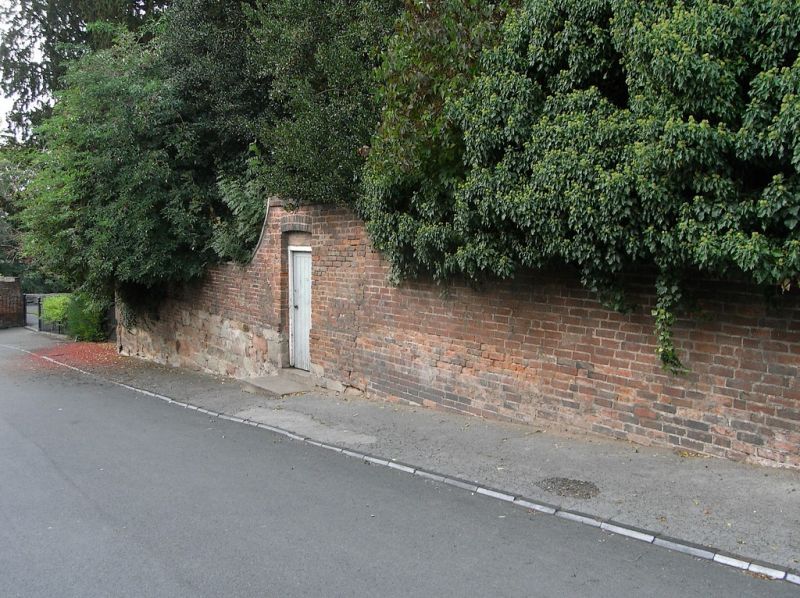
Boundary wall to gardens of Nos. 13 & 14 College Green
including its continuation (as railings/gates/wall) westwards
to its intersection with the Monastery Wall adjacent to the
river, and its continuation eastwards (as wall with railings
over) towards the Green. Possibly re-using 'quarried'
materials from C14 monastery but with later additions and
alterations mainly from the C18 & C19. Sandstone in red,
cream, and grey/green; red brick; wrought- and cast-iron.
Boundary wall: overall length approx. 77 metres (45m. N/S,
32m. E/W); height varies from approx. 2.5 metres to 4.5
metres. All the western section of wall is brick over regular
coursed masonry of rectangular, smooth-faced blocks; typically
two to eight courses (0.6m.- 1.5m.) high. Thin oversailing
coping of rectangular-section with cambered top-face in stone.
Changes in wall height achieved by curved ramps, copings
profiled to suit. Northern end of wall terminates in remains
of Monastery Dormitory; to south, curved intersection between
the two sections; wall to southern boundary is of similar
construction of brick over stone. Pierced to left of centre by
pedestrian opening with cambered arch over and vertically
boarded door. Wall to right of door is predominantly brick
with approx. 1m. length of stonework visible at ground-level.
Stone coping and ramp detail as to west but also terminated by
brick-on-edge and brick-on-flat coping. Railings and wall
running from SW corner of wall to riverside wall on Kleve Walk
(qv): railings extend for approx. 20 metres, with C19 brick
return in short section of approx. 10 metres to No.12B(qv);
approx. 1.4m. high; rectangular-section top, middle, and
bottom rail and main posts; circular cross-section vertical
railings alternate full- and half-height, arrow head finials,
those to dog bars broken-off; gates to left and right in
matching design to railings; cast-iron hinge and latch posts,
octagonal with moulded cap and plinth, identified in casting
as made by 'J & F Hall of Worcester.' To west of railings is
approx. 20 metre length of wall mostly some 2.5 metres high of
brick with approx. two courses of stone at foot, brick-on-edge
coping; final 6 metres is all stone construction similar
detail to main boundary wall, 1 metre high with half-round
blue brick coping. Wall with railings over continuing to east
of boundary wall: length approx. 14 metres, height from
approx. 1.2 - 2.8 metres; regular coursed stone as per main
boundary wall, cambered-top oping; wall terminated at east end
by matching stone pillar; square in section with stopped
chamfers to arrisses on chamfered-top plinth; moulded cap.
Approx. 1.4 metre high railings set into wall coping, moulded
top-rail, circular-section vertical railings with ornate
arrow-head finials.
HISTORICAL NOTE: Robert Willis Map from 1863 shows boundary
wall to nos. 13 & 14 annotated as 'modern wall'. Railings to
west of boundary wall are not shown on the Willis map or the
First Edition O.S. Map of 1886. (Architectural Journal
20:83-133: Robert Willis: Architectural History of the
Cathedral & Monastery of Worcester: 1863-: 254-318; Worcester
Cathedral Publications: Philip Barker: A Short Architectural
History of Worcester Cathedral: Worcester: 1994-).
External links are from the relevant listing authority and, where applicable, Wikidata. Wikidata IDs may be related buildings as well as this specific building. If you want to add or update a link, you will need to do so by editing the Wikidata entry.


Other nearby listed buildings
