Approximate Location Map
Large Map »
Latitude: 52.786 / 52°47'9"N
Longitude: -0.1499 / 0°8'59"W
OS Eastings: 524866
OS Northings: 322541
OS Grid: TF248225
Mapcode National: GBR HX9.BX5
Mapcode Global: WHHMM.N7TJ
Plus Code: 9C4XQVP2+C2
Entry Name: High Bridge
Listing Date: 24 July 1975
Grade: II
Source: Historic England
Source ID: 1063997
English Heritage Legacy ID: 197245
ID on this website: 101063997
Location: Spalding, South Holland, Lincolnshire, PE11
County: Lincolnshire
District: South Holland
Electoral Ward/Division: Spalding Castle
Parish: Non Civil Parish
Built-Up Area: Spalding
Traditional County: Lincolnshire
Lieutenancy Area (Ceremonial County): Lincolnshire
Church of England Parish: Spalding St Mary and St Nicolas
Church of England Diocese: Lincoln
Tagged with: Bridge
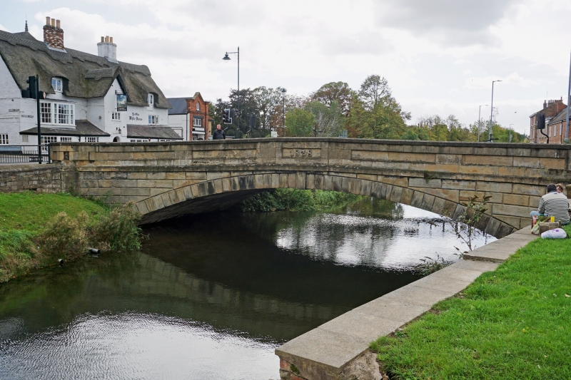
BRIDGE STREET
1.
5313
(East Side)
High Bridge
TF 2421 1/19 24.7.75.
II GV
2.
Stone bridge of a single arch, with 5-Panelled parapet, the centre with date
1838.
High Bridge form a visual group with the buildings in Bridge Street, Church
Street, Church Gate and High Street.
Listing NGR: TF2486622541
External links are from the relevant listing authority and, where applicable, Wikidata. Wikidata IDs may be related buildings as well as this specific building. If you want to add or update a link, you will need to do so by editing the Wikidata entry.


Other nearby listed buildings
