Approximate Location Map
Large Map »
Latitude: 51.291 / 51°17'27"N
Longitude: 0.4237 / 0°25'25"E
OS Eastings: 569096
OS Northings: 157443
OS Grid: TQ690574
Mapcode National: GBR NPC.ZYN
Mapcode Global: VHJM5.9TC5
Plus Code: 9F327CRF+CF
Entry Name: Cobb's Hall
Listing Date: 25 February 1987
Grade: II
Source: Historic England
Source ID: 1070529
English Heritage Legacy ID: 179306
ID on this website: 101070529
Location: Mill Street, Tonbridge and Malling, Kent, ME19
County: Kent
District: Tonbridge and Malling
Civil Parish: East Malling and Larkfield
Traditional County: Kent
Lieutenancy Area (Ceremonial County): Kent
Church of England Parish: East Malling St James
Church of England Diocese: Rochester
Tagged with: Building
EAST MALLING & LARKFIELD BROADWATER ROAD
TQ 65 NE
(east side)
7/133
Cobb's Hall
-
- II
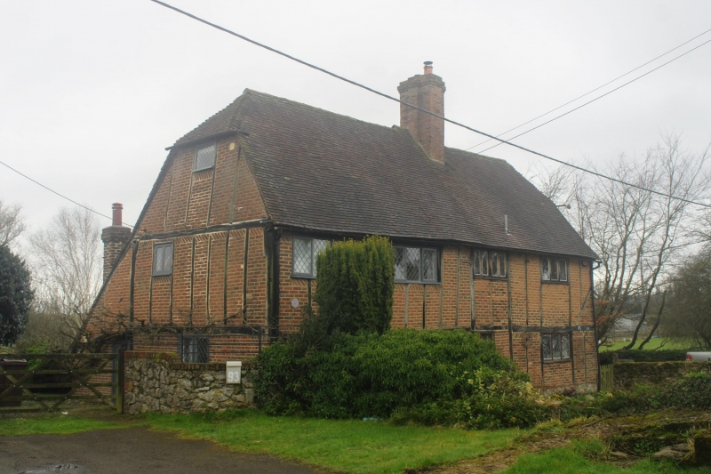
Farmhouse. Early C17. Timber-framed with red brick infilling; red and blue
brick ground-floor to right side, with tile-hanging above. Plain and tiled half-
hipped roof with tall red brick stack off-centre to right. Baffle entry plan.
2 storeys and garrets; almost regular 4 window front, C20 diamond lattice
casements. Boarded door to left of right-hand window, boarded door also at
right-hand end. C20 extensions to rear.
Listing NGR: TQ6909657443
External links are from the relevant listing authority and, where applicable, Wikidata. Wikidata IDs may be related buildings as well as this specific building. If you want to add or update a link, you will need to do so by editing the Wikidata entry.


Other nearby listed buildings
