Approximate Location Map
Large Map »
Latitude: 53.8214 / 53°49'16"N
Longitude: -3.0563 / 3°3'22"W
OS Eastings: 330559
OS Northings: 436637
OS Grid: SD305366
Mapcode National: GBR ZJG.BM
Mapcode Global: WH858.06WT
Plus Code: 9C5RRWCV+GF
Entry Name: Two shelters on Princess Parade, Blackpool
Listing Date: 20 October 1983
Last Amended: 13 August 2021
Grade: II
Source: Historic England
Source ID: 1072013
English Heritage Legacy ID: 183674
ID on this website: 101072013
Location: Blackpool, Lancashire, FY1
County: Blackpool
Electoral Ward/Division: Claremont
Parish: Non Civil Parish
Built-Up Area: Blackpool
Traditional County: Lancashire
Lieutenancy Area (Ceremonial County): Lancashire
Church of England Parish: Blackpool St Peter
Church of England Diocese: Blackburn
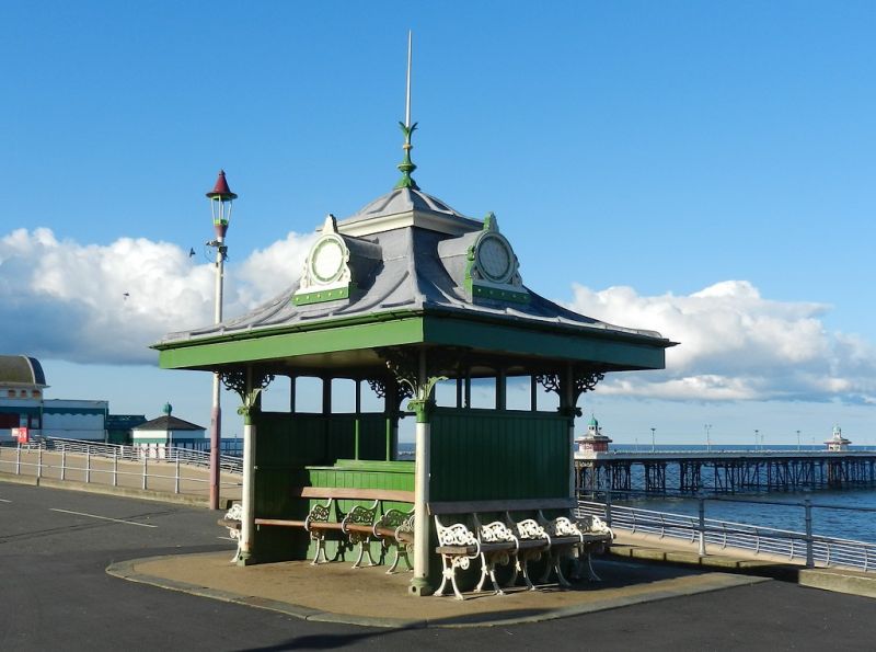
Two cast-iron promenade shelters of 1903, refurbished and relocated in the early C21, by Walter MacFarlane and Co of the Saracen Foundry, Glasgow.
Two promenade shelters of 1903, relocated in 2012, by Walter MacFarlane and Co of the Saracen foundry, Glasgow.
MATERIALS: cast-iron columns, brackets, dormers, gutters and finials with wooden screens, and lead-covered roofs. Steel bench castings.
DESCRIPTION: each of almost-square plan, with slim columns at the corners, linked by screens at each end, and with an axial screen aligned north-south. The round columns have foliate capitals and each has three foliate brackets in open arabesque pattern, supporting the diagonal timbers of the roof soffit. The emphatically-ribbed swept roofs have a blind round dormer on each side, and a depressed-ogee cap with needle finial. Ogee gutters discharge via the columns. The screens have tongue-and-groove lower panels and (now unglazed) upper glazing panels. The axial screens have concave tongue-and-groove, accommodating a curved bench on both sides. The ends have straight benches.
Many components are identical to, or very closely match, designs in a MacFarlanes catalogue of approximately 1890, including: dormers (type 39 on p644); columns (type 130, p572); brackets (type 53, p549) and finials (type 20, p97 or type 117, p102). The bench castings match type 11, p402.
In May 1903 renowned Glasgow iron-founders Walter MacFarlane and Co (MacFarlanes) were commissioned by Blackpool Corporation to supply ten shelters for the ‘new promenade’, thought to mean the south shore where the promenade had recently been extended southwards from Station Road to Balmoral Road. Almost square in plan, they had swept roofs, supported by classical columns and foliate brackets. Four were reported to be completed by the end of September, which probably means four pairs, as they were placed in pairs flanking steps down to the beach, and some committee minutes refer to a pair as one shelter. The 1911 1:2,500 Ordnance Survey (OS) map (surveyed 1909) shows eleven pairs of shelters between south and central piers, seven of which are later and accounted for below. This suggests that the other four pairs are from this original order, sited opposite Rawcliffe Street, Shaw Road, Alexandra Road and Crystal Road. The two ‘missing’ shelters from the 1903 order are thought to have been sited unpaired at the north shore, on the middle walk.
In 1904 ten more shelters for the promenade were commissioned to be supplied and fitted by Radford and Greaves of Derby, and these are also thought to have been manufactured by MacFarlanes. These ten shelters were in place by the end of September 1904. Four more shelters were ordered against Radford and Greaves’ additional tender of November 1904. These fourteen shelters were sited in pairs opposite Woodfield Road, Wellington Road, Waterloo Avenue (now Barton Avenue), Trafalgar Road, Foxhall Square; and Yorkshire Street and Waterloo Road.
Early alterations
Alterations to the windows, and to lower the wooden partitions of some of the shelters, were approved in 1905, probably to increase the visibility of occupants and reduce vandalism. Storm damage to the glazing and ‘sashes’ of some of the shelters was noted in 1907 (they were right on the sea wall).
Relocation history
By the survey for the 1961 1:2,500 OS map, the south-shore shelters had all been removed except those opposite Alexandra Road, Wellington Road and Trafalgar Road. These were listed in pairs in 1983 (National Heritage List for England – NHLE – entries 1072013, 1072012 and 1205804), along with the two north-shore shelters (NHLE 1362392 and 1280483).
Around 2005 the south-shore listed shelters were removed to allow the building of the new promenade and sea defences. In 2012, they were re-erected at Princess Parade, close to the town’s war memorial (NHLE 1072010), but not in their original pairs. The commissioning history above, and the differences between two of the six shelters when compared with the other four (see below), suggest that the two shelters in this List entry date from 1903 and originally stood at Alexandra Road, while the four between them date from 1904 and stood at Wellington and Trafalgar Roads.
Later alterations
These shelters have benches with accurate reproduction castings by Trumetals Foundry Limited, which operated from 1951 until around 1999. The design matches a design in a MacFarlanes catalogue of around 1890. Brackets and finials also match designs in the catalogue although most brackets are reportedly recastings taken from an original around 2005. The shelters no longer have the palmette terminals which originally adorned the eaves and corners, accentuating the effect of the swept roof. The screens also have woodwork with modern routered detailing, and have lost all glazing. This pair also has round dormers, finials and columns closely-matching designs in the catalogue.
Walter MacFarlane and Company
Walter MacFarlane and Company were one of the most prolific suppliers of architectural ironwork in the world, operating from 1851 to 1967 out of ‘Saracen Foundry’ (in three successive locations). In 1875 the foundry covered 80 acres and employed over 1,400 people. Over 80 cast-iron listed structures in England are attributed to them, including telephone kiosks, sewage ventilator shafts, lamp posts, drinking fountains, urinals and bandstands. More listed examples of their work are known but unattributed, and the true number is probably several hundred.
The two shelters, at the north and south ends of a group of six shelters on Princess Parade in Blackpool, promenade shelters of 1903, relocated in 2012, are listed at Grade II for the following principal reasons:
Architectural interest:
* increasingly-rare survivals of good quality Edwardian street shelters, particularly redolent of the seaside, and retaining many of their original design features (some in accurate replica).
Group value:
* for their strong visual relationship with the others in the group, and with the listed North Pier and the listed war memorial.
External links are from the relevant listing authority and, where applicable, Wikidata. Wikidata IDs may be related buildings as well as this specific building. If you want to add or update a link, you will need to do so by editing the Wikidata entry.


Other nearby listed buildings
