Approximate Location Map
Large Map »
Latitude: 53.8485 / 53°50'54"N
Longitude: -2.9775 / 2°58'39"W
OS Eastings: 335787
OS Northings: 439580
OS Grid: SD357395
Mapcode National: GBR 7RNY.55
Mapcode Global: WH853.7JDK
Plus Code: 9C5VR2XC+9X
Entry Name: End Cottage Old Farm
Listing Date: 16 August 1983
Grade: II
Source: Historic England
Source ID: 1072403
English Heritage Legacy ID: 184782
ID on this website: 101072403
Location: Little Poulton, Wyre, Lancashire, FY6
County: Lancashire
District: Wyre
Electoral Ward/Division: Breck
Parish: Non Civil Parish
Built-Up Area: Poulton-le-Fylde
Traditional County: Lancashire
Lieutenancy Area (Ceremonial County): Lancashire
Church of England Parish: Poulton-le-Fylde St Chad
Church of England Diocese: Blackburn
Tagged with: Building
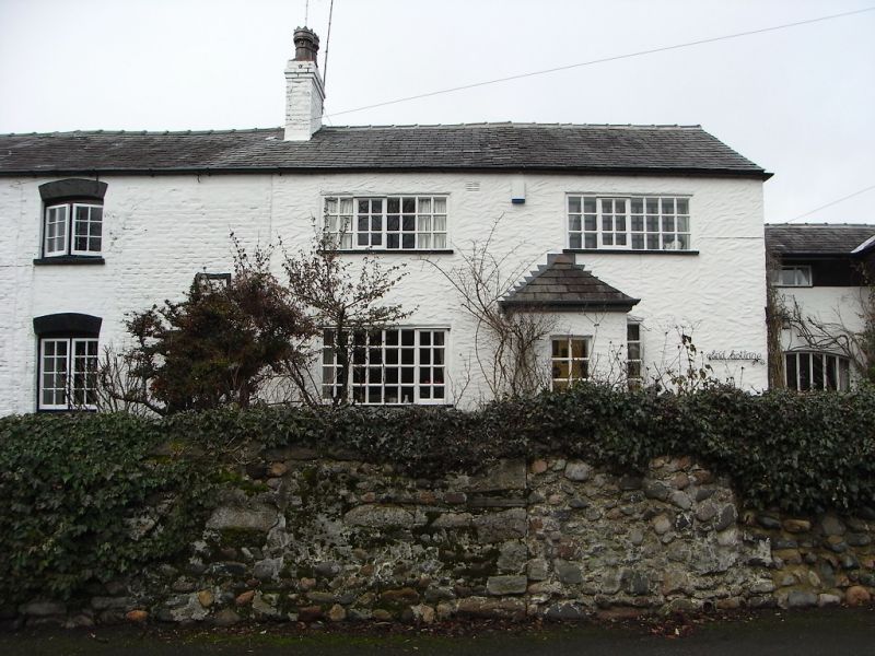
SD 33 NE POULTON-LE-FYLDE LITTLE POULTON LANE
4/5 No. 28 (Old Farm) and
No. 30 (End Cottage)
II
Farmhouse, dated 1723, now house and cottage as separate properties. Brick,
whitewashed, slate roof. Originally 3 unit baffle-entry plan, with gable
chimney stack to left and axial chimney stack between 2nd and 3rd bays, the
third bay now incorporated in No. 30 adjoining. 2 storeys. Door with wooden
canopy on right side of No. 28; 2 casement windows on each floor, all with
glazing bars, stone sills and slightly arched brick heads; all now have
wooden shutters. Square datestone over door, lettered P , said to be
H G
1723
the initials of Henry Porter (J. Porter, History of the Fylde, 1876, p.215).
Rear wall contains, inter alia, a 3-light stair window with wooden mullions.
Interior: baffle-entry (former opening to 3rd bay now blocked), heck with
glazed peephole; house part has 2 chamfered and stopped bridging beams, wide
hearth with crude bressumer of light scantling, dog-leg staircase against
rear wall. No. 30 included in item because bay adjoining has bridging beams
matching those of No. 28, with scarf-joints near chimney breast indicating
former hearth bressumer; and internal window in what was once an outer gable
wall.
Listing NGR: SD3578739580
External links are from the relevant listing authority and, where applicable, Wikidata. Wikidata IDs may be related buildings as well as this specific building. If you want to add or update a link, you will need to do so by editing the Wikidata entry.


Other nearby listed buildings
