Approximate Location Map
Large Map »
Latitude: 51.284 / 51°17'2"N
Longitude: 1.0705 / 1°4'13"E
OS Eastings: 614216
OS Northings: 158352
OS Grid: TR142583
Mapcode National: GBR TY2.FGJ
Mapcode Global: VHLGF.HZSK
Plus Code: 9F3373MC+J5
Entry Name: 2, London Road
Listing Date: 3 December 1949
Grade: II
Source: Historic England
Source ID: 1079087
English Heritage Legacy ID: 439499
ID on this website: 101079087
Location: St Dunstan's, Canterbury, Kent, CT2
County: Kent
District: Canterbury
Electoral Ward/Division: St Stephen's
Parish: Non Civil Parish
Built-Up Area: Canterbury
Traditional County: Kent
Lieutenancy Area (Ceremonial County): Kent
Tagged with: Building
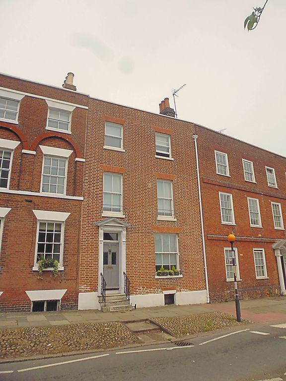
1.
944 LONDON ROAD
(North West Side)
No 2
TR 1458 SW 1/132 3.12.49.
II GV
2.
Late C18. 3 storeys and basement red brick. Stone coping. 2 sashes with
verticals only. Left side doorcase with semi-hood, brackets and 6 fielded
panels. 4 stone steps with wrought iron hand rails. Footscraper.
Nos 1 to 15 (consec) paving and cobbles in front os Nos 1 to 15 (consec)
together with Nos 1 & 3 Whitstable Road form a group.
Listing NGR: TR1421258353
External links are from the relevant listing authority and, where applicable, Wikidata. Wikidata IDs may be related buildings as well as this specific building. If you want to add or update a link, you will need to do so by editing the Wikidata entry.


Other nearby listed buildings
