Approximate Location Map
Large Map »
Latitude: 53.685 / 53°41'6"N
Longitude: -0.4417 / 0°26'30"W
OS Eastings: 503012
OS Northings: 422080
OS Grid: TA030220
Mapcode National: GBR TTCT.5R
Mapcode Global: WHGFX.5MYV
Plus Code: 9C5XMHP5+28
Entry Name: 57, High Street
Listing Date: 17 September 1976
Grade: II
Source: Historic England
Source ID: 1083055
English Heritage Legacy ID: 165599
ID on this website: 101083055
Location: Barton-upon-Humber, North Lincolnshire, DN18
County: North Lincolnshire
Civil Parish: Barton-upon-Humber
Built-Up Area: Barton-upon-Humber
Traditional County: Lincolnshire
Lieutenancy Area (Ceremonial County): Lincolnshire
Church of England Parish: Barton on Humber St Mary
Church of England Diocese: Lincoln
Tagged with: Building
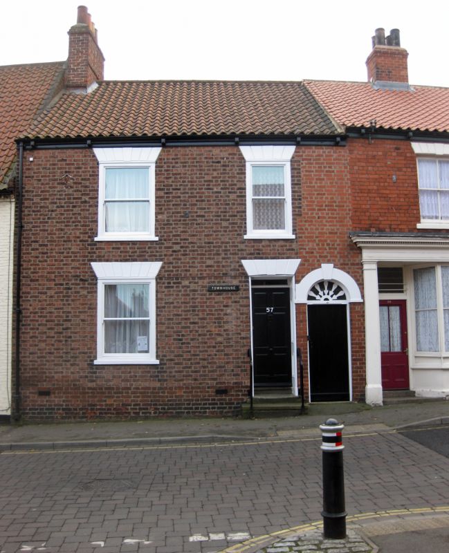
1.
5264 HIGH STREET
(South Side)
No 57
TA 0322 2/205
II GV
2.
Early C19. 2 storeys in brick with pantile roof with 1 dormer and wood eaves cornice.
2 windows, rusticated lintels with keystone. 1 window to ground floor. Doorway
with panelled reveals and inset half-glazed panelled door, rectangular fanlight,
rusticated lintel with longer keystone. Included as part of a group.
Nos 49 to 59 (odd), No 59A, and Nos 61 to 75 (odd) form a group of which Nos 59,
59A and 61 are local interest only.
Listing NGR: TA0301222080
External links are from the relevant listing authority and, where applicable, Wikidata. Wikidata IDs may be related buildings as well as this specific building. If you want to add or update a link, you will need to do so by editing the Wikidata entry.


Other nearby listed buildings
