Approximate Location Map
Large Map »
Latitude: 51.1135 / 51°6'48"N
Longitude: 0.4607 / 0°27'38"E
OS Eastings: 572333
OS Northings: 137786
OS Grid: TQ723377
Mapcode National: GBR PT2.39G
Mapcode Global: VHJN4.X8XR
Plus Code: 9F324F76+97
Entry Name: The Star and Eagle Hotel and wall attached
Listing Date: 9 June 1952
Grade: II
Source: Historic England
Source ID: 1084673
English Heritage Legacy ID: 169539
ID on this website: 101084673
Location: Goudhurst, Tunbridge Wells, Kent, TN17
County: Kent
District: Tunbridge Wells
Civil Parish: Goudhurst
Built-Up Area: Goudhurst
Traditional County: Kent
Lieutenancy Area (Ceremonial County): Kent
Tagged with: Building
This list entry was subject to a Minor Amendment on 14 April 2023 to amend the name and address and reformat the text to current standards
TQ 7237-7337
15/189
GOUDHURST
HIGH STREET (south side)
The Star and Eagle Hotel and wall attached
(Formerly listed as Star and Eagle Inn and wall attached)
9.6.52
GV
II
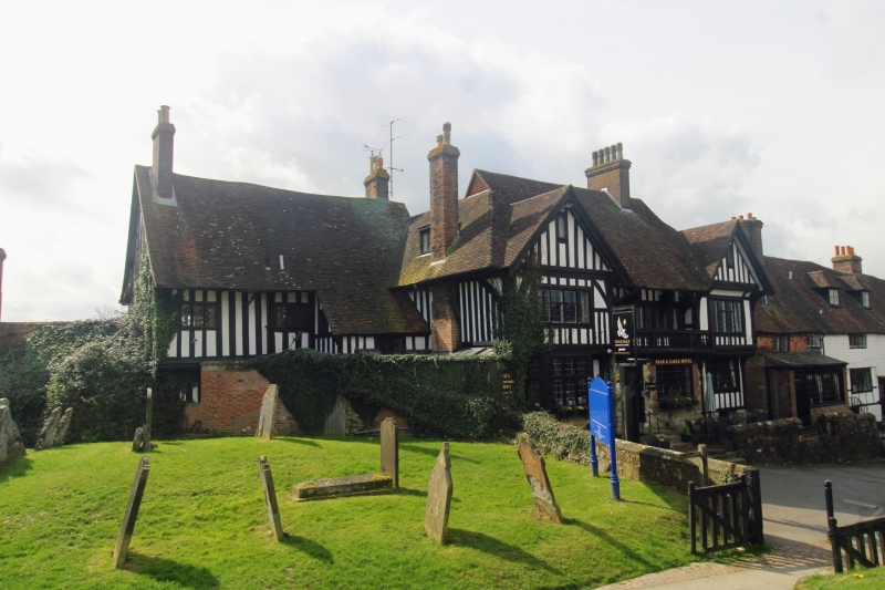
Inn. C15 and mid C20. Timber-framed and exposed with plaster infill on red brick and sandstone base, the rear elevations tile hung on red brick ground floor. Two staggered principal ranges, the front, entrance elevation originally C16, altered c.1800 and C19, late 1980s.
Two storeys and garret on sandstone plinth, with jettied gabled wings to left and to right, with recessed central bays. The ground floor built out with balustrade over. Covered and jettied gable to right, gables with moulded bargeboards. Stacks to right and at end left. Leaded wooden casements in gables and to first floor, and mullioned and transomed canted bay to left, to centre, with flush window to right. Central half-glazed door, with basement openings to centre. Rear left range: C16, continuous jettied two storey range, with moulded bressummer supported on dragon post, with projecting pentice to re-entrant angle, and stacks to end left and end right. Four and three-light mullioned windows. Across the re-entrant angle joining the two wings is a brick wall, part of the churchyard wall, about 1.8 metres high, of red brick, with segmentally headed boarded door to centre. Single storey wing to left, entered by rear courtyard, of red and blue brick, with central stack. Rear elevation of one storey with boarded door and two glazing bar sashes. The C16 range of two storeys, attic and basement to rear, with irregular fenestration of sashes and casements, with central canted bay, and projecting wings of various dates.
Interior: fully exposed frame in part reconstructed, with turned baluster stair (with detailable
"burglar's terror" newel), remains of C18 shop front (carved wooden post and window heads exposed in Ladies' Lavatories), and stone newel stair to cellar (reported) passage to adjacent church). An Inn at least since 1600 (recorded as the Black Spreadeagle). See Igglesden, Vol 12, 26-27; see also Kent Life, 1969, December issue).
Listing NGR: TQ7233537785
External links are from the relevant listing authority and, where applicable, Wikidata. Wikidata IDs may be related buildings as well as this specific building. If you want to add or update a link, you will need to do so by editing the Wikidata entry.


Other nearby listed buildings
