Approximate Location Map
Large Map »
Latitude: 51.2762 / 51°16'34"N
Longitude: 1.0757 / 1°4'32"E
OS Eastings: 614619
OS Northings: 157505
OS Grid: TR146575
Mapcode National: GBR TY2.W8K
Mapcode Global: VHLGM.L5KZ
Plus Code: 9F3373GG+F7
Entry Name: 44 and 45, Castle Street
Listing Date: 7 September 1973
Last Amended: 7 July 1993
Grade: II
Source: Historic England
Source ID: 1085097
English Heritage Legacy ID: 170508
ID on this website: 101085097
Location: Canterbury, Kent, CT1
County: Kent
District: Canterbury
Town: Canterbury
Electoral Ward/Division: Westgate
Parish: Non Civil Parish
Built-Up Area: Canterbury
Traditional County: Kent
Lieutenancy Area (Ceremonial County): Kent
Tagged with: Building
1.
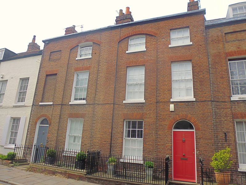
944 CASTLE STREET
(North West Side)
Nos 44 and 45
TR 1457 NE 4/262
II GV
2.
Early C19 pair. 3 storeys and basement red brick. Old tiled roof. 2 window
spaces to each. 1 blank to No 44. 2 centre windows set in arched recesses.
Sashes with glazing bars intact. 6 panelled doors with semi-circular fanlights.
Nos 40 to 48 (consec) form a group.
Listing NGR: TR1461557505
External links are from the relevant listing authority and, where applicable, Wikidata. Wikidata IDs may be related buildings as well as this specific building. If you want to add or update a link, you will need to do so by editing the Wikidata entry.


Other nearby listed buildings
