Approximate Location Map
Large Map »
Latitude: 51.282 / 51°16'55"N
Longitude: 1.0837 / 1°5'1"E
OS Eastings: 615150
OS Northings: 158172
OS Grid: TR151581
Mapcode National: GBR TY2.JT3
Mapcode Global: VHLGM.Q1SJ
Plus Code: 9F3373JM+RF
Entry Name: 83, Broad Street
Listing Date: 7 September 1973
Grade: II
Source: Historic England
Source ID: 1085106
English Heritage Legacy ID: 170436
ID on this website: 101085106
Location: Northgate, Canterbury, Kent, CT1
County: Kent
District: Canterbury
Electoral Ward/Division: Westgate
Parish: Non Civil Parish
Built-Up Area: Canterbury
Traditional County: Kent
Lieutenancy Area (Ceremonial County): Kent
Tagged with: Building
1.
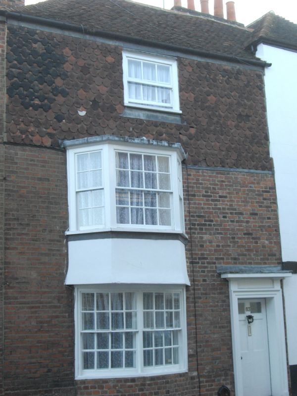
944 BROAD STREET
(South West Side)
No 83
TR 1558 SW 3/295
II GV
2.
C18 or early C19 facade. 3 storeys brick. Second floor is faced with fishscale
tiles. Tiled roof, 1 sash. First floor has a C19 3-light bay. The ground
floor has a Georgian double-hung curved bow. Right side doorcase has cornice
and moulded architrave and a 6 panelled door. 2 panels cut out to form the
fanlight.
Nos 80 to 89 (consec) form a group.
Listing NGR: TR1514958170
External links are from the relevant listing authority and, where applicable, Wikidata. Wikidata IDs may be related buildings as well as this specific building. If you want to add or update a link, you will need to do so by editing the Wikidata entry.


Other nearby listed buildings
