Approximate Location Map
Large Map »
Latitude: 51.2785 / 51°16'42"N
Longitude: 1.0835 / 1°5'0"E
OS Eastings: 615150
OS Northings: 157774
OS Grid: TR151577
Mapcode National: GBR TY2.YJT
Mapcode Global: VHLGM.Q4N8
Plus Code: 9F3373HM+9C
Entry Name: Annexe to No 12
Listing Date: 3 May 1967
Grade: II
Source: Historic England
Source ID: 1085112
English Heritage Legacy ID: 170445
ID on this website: 101085112
Location: Canterbury, Kent, CT1
County: Kent
District: Canterbury
Electoral Ward/Division: Westgate
Parish: Non Civil Parish
Built-Up Area: Canterbury
Traditional County: Kent
Lieutenancy Area (Ceremonial County): Kent
Tagged with: Building
1.
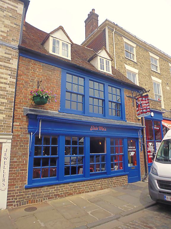
944 BURGATE
(North East Side)
Annexe to No 12
TR 1557 NW 5/251
II GV
2.
C17 and later. 2 storeys red brick with steeply pitched old tiled roof with
2 hipped dormers. 1 restored triple sash. Neo-Georgian shopfront.
Nos 11 to 16 (consec) and annexe to No 12 form a group.
Listing NGR: TR1515357791
External links are from the relevant listing authority and, where applicable, Wikidata. Wikidata IDs may be related buildings as well as this specific building. If you want to add or update a link, you will need to do so by editing the Wikidata entry.


Other nearby listed buildings
