Approximate Location Map
Large Map »
Latitude: 51.3871 / 51°23'13"N
Longitude: 1.3833 / 1°23'0"E
OS Eastings: 635499
OS Northings: 170767
OS Grid: TR354707
Mapcode National: GBR WZS.VZT
Mapcode Global: VHLG6.XDPJ
Plus Code: 9F3399PM+R8
Entry Name: Former Holy Trinity Hall
Listing Date: 22 February 1973
Grade: II
Source: Historic England
Source ID: 1088967
English Heritage Legacy ID: 356551
ID on this website: 101088967
Location: Margate, Thanet, Kent, CT9
County: Kent
District: Thanet
Electoral Ward/Division: Margate Central
Parish: Non Civil Parish
Built-Up Area: Margate
Traditional County: Kent
Lieutenancy Area (Ceremonial County): Kent
Tagged with: Building
HAWLEY SQUARE
1.
1380
(North Side)
Former Holy
Trinity Hall
TR 3570 NW 1/173
TR 3570 NE 6/173
II GV
2.
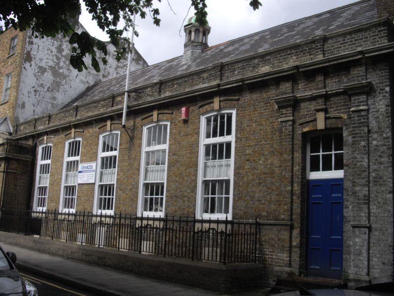
Erected in 1896 but is early C18 style. 1 storey and basement brown brick.
Slate roof with cupola. Cornice and parapet. 5 tall windows with glazing bars
intact. Porch at west end. Included for group value.
Nos 4 to 6 (consec) former Holy Trinity Hall, former Methodist Chapel
and Nos 12 to 16A (consec) form a group
Listing NGR: TR3549970767
External links are from the relevant listing authority and, where applicable, Wikidata. Wikidata IDs may be related buildings as well as this specific building. If you want to add or update a link, you will need to do so by editing the Wikidata entry.


Other nearby listed buildings
