Approximate Location Map
Large Map »
Latitude: 51.7316 / 51°43'53"N
Longitude: -2.2492 / 2°14'56"W
OS Eastings: 382888
OS Northings: 203687
OS Grid: SO828036
Mapcode National: GBR 1MQ.G5H
Mapcode Global: VH94X.YQTW
Plus Code: 9C3VPQJ2+M8
Entry Name: Peaked Elm Farmhouse
Listing Date: 24 February 1987
Grade: II
Source: Historic England
Source ID: 1090728
English Heritage Legacy ID: 131921
ID on this website: 101090728
Location: Selsley, Stroud, Gloucestershire, GL5
County: Gloucestershire
District: Stroud
Civil Parish: King's Stanley
Traditional County: Gloucestershire
Lieutenancy Area (Ceremonial County): Gloucestershire
Church of England Parish: Selsley All Saints
Church of England Diocese: Gloucester
Tagged with: Farmhouse
SO 8203-8303 KING'S STANLEY SELSLEY WEST
14/47 Peaked Elm Farmhouse
28.6.60
II
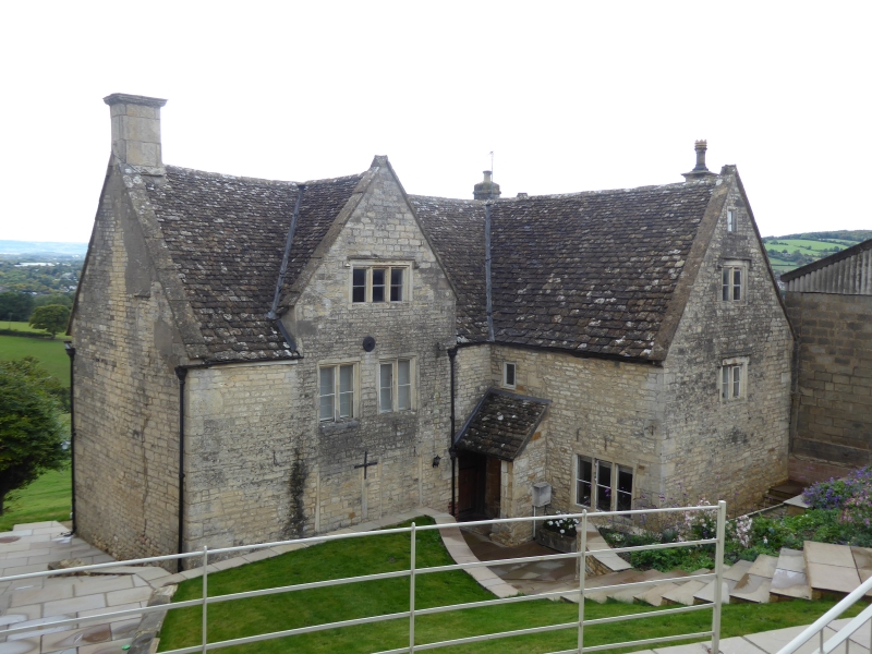
Detached farmhouse. Dated 1632; late C17 addition and rebuilding;
C19 alterations. Random and coursed rubble limestone; ashlar
chimneys; stone slate to front roof slopes, plain tile to rear.
Two-storey with attic; L-plan. East front: parapet gable with
cross-roll saddle extends forward to right with single-window
fenestration to upper floor and attic, both 2-light recessed
chamfered mullioned casements with hoodmould. South side of wing
has C19 3-light to ground floor and blocked doorway to left with
Tudor-arched lintel inscribed with I W S 1632. Part of hoodmould
over with rosette to square stop; lean-to roof to stone-sided
porch, now serving doorway with timber lintel and plank door in
main range to left. C20 upper floor casement above porch with
remains of hoodmould. Parapet attic gable to main range with 3-
light casement; two 2-light to upper floor; blocked 2-light to
ground floor. South end: gable-mounted ashlar chimney with egg
and dart enriched moulded cap; blocked off-centre single-light
attic opening with hoodmould. West side: 4-window fenestration to
ground floor, formerly sashes with deep stone lintels, now C20
casements. Two upper floor windows, 3-light casement with
hoodmould and 2-light to right without hood. North end: 2 gables,
right is end of main range with single-window fenestration and off-
centre C20 concrete chimney; lean-to below with C19 fixed light.
Left gable end projects forward: off-centre blocked attic opening
with mutilated hoodmould; gable-mounted chimney with moulded cap;
further lean-to below with pantile roof.
Interior: west-facing room has early C19 plaster frieze; panelled
shutters to windows. Beams in east wing have stepped pointed
chamfer stops.
(N.M. Herbert, 'King's Stanley' in V.C.H. Glos. x, 1972, pp 242-
257)
Listing NGR: SO8288703688
External links are from the relevant listing authority and, where applicable, Wikidata. Wikidata IDs may be related buildings as well as this specific building. If you want to add or update a link, you will need to do so by editing the Wikidata entry.


Other nearby listed buildings
