Approximate Location Map
Large Map »
Latitude: 51.3895 / 51°23'22"N
Longitude: 1.3837 / 1°23'1"E
OS Eastings: 635515
OS Northings: 171044
OS Grid: TR355710
Mapcode National: GBR WZS.W2V
Mapcode Global: VHLG6.XBWM
Plus Code: 9F3399QM+RF
Entry Name: The George Public House
Listing Date: 22 February 1973
Grade: II
Source: Historic England
Source ID: 1094634
English Heritage Legacy ID: 356577
ID on this website: 101094634
Location: Margate, Thanet, Kent, CT9
County: Kent
District: Thanet
Electoral Ward/Division: Margate Central
Parish: Non Civil Parish
Built-Up Area: Margate
Traditional County: Kent
Lieutenancy Area (Ceremonial County): Kent
Tagged with: Pub
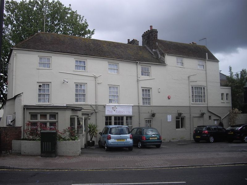
HAWLEY STREET
1.
1380
(East Side)
No 44
(The George
Public House)
TR 3571 SE 3/180
II
2.
Early C19. 3 storeys mostly pebble dash. Tiled roof. 6 sashes set in
moulded architraves with glazing bars intact. Early C19 bar front and simple
doorcases. 1st floor has a 3-light sash.
Listing NGR: TR3551571044
External links are from the relevant listing authority and, where applicable, Wikidata. Wikidata IDs may be related buildings as well as this specific building. If you want to add or update a link, you will need to do so by editing the Wikidata entry.


Other nearby listed buildings
