Approximate Location Map
Large Map »
Latitude: 51.3893 / 51°23'21"N
Longitude: 1.3804 / 1°22'49"E
OS Eastings: 635286
OS Northings: 171005
OS Grid: TR352710
Mapcode National: GBR WZS.V47
Mapcode Global: VHLG6.WB4T
Plus Code: 9F3399QJ+P5
Entry Name: 5, High Street
Listing Date: 22 February 1973
Grade: II
Source: Historic England
Source ID: 1094636
English Heritage Legacy ID: 356580
ID on this website: 101094636
Location: Margate, Thanet, Kent, CT9
County: Kent
District: Thanet
Electoral Ward/Division: Margate Central
Parish: Non Civil Parish
Built-Up Area: Margate
Traditional County: Kent
Lieutenancy Area (Ceremonial County): Kent
Tagged with: Building
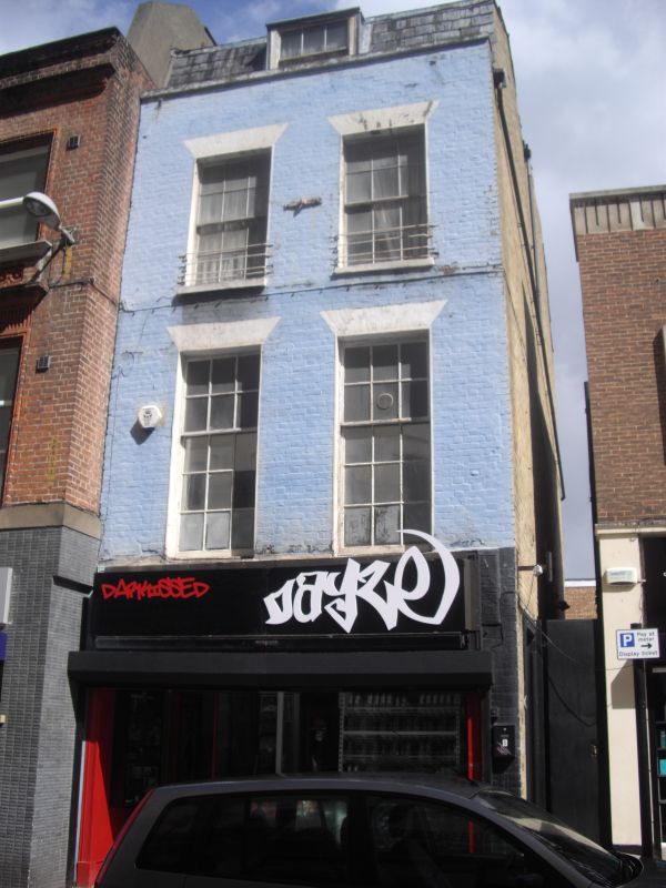
HIGH STREET
1.
1380
(East Side)
No 5
TR 3571 SW 2/182
II
2.
Late C18 to early C19. 3 storeys and attics painted brick. Slate mansard
roof with 1 dormer. Stone coping. 2 sashes with verticals only on 2nd floor,
glazing bars intact on 1st floor. Stone cills. Modern shopfront.
Listing NGR: TR3528671005
External links are from the relevant listing authority and, where applicable, Wikidata. Wikidata IDs may be related buildings as well as this specific building. If you want to add or update a link, you will need to do so by editing the Wikidata entry.


Other nearby listed buildings
