Approximate Location Map
Large Map »
Latitude: 51.3906 / 51°23'26"N
Longitude: 1.3867 / 1°23'12"E
OS Eastings: 635713
OS Northings: 171168
OS Grid: TR357711
Mapcode National: GBR WZS.PF2
Mapcode Global: VHLG6.Z9FV
Plus Code: 9F3399RP+6M
Entry Name: 53-57, Trinity Square
Listing Date: 22 February 1973
Grade: II
Source: Historic England
Source ID: 1094690
English Heritage Legacy ID: 356698
ID on this website: 101094690
Location: Margate, Thanet, Kent, CT9
County: Kent
District: Thanet
Electoral Ward/Division: Margate Central
Parish: Non Civil Parish
Built-Up Area: Margate
Traditional County: Kent
Lieutenancy Area (Ceremonial County): Kent
Tagged with: Building
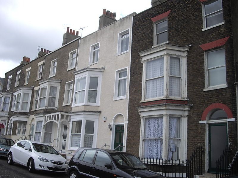
TRINITY SQUARE
1.
1380
(East Side)
Nos 53 to 57 (consec)
TR 3571 SE 3/324
II GV
2.
Early C19. 3 storeys and basement brown brick. Nos 55 & 56 are faced with
pebble dash. Stone coping. 2 sashes to each with some glazing bars intact.
3 light canted bays through 2 floors. Simple round-headed doorcases. Steps
to street and area railings. Modern wooden porch to No 55.
Nos 53 to 66 (consec) form a group
Listing NGR: TR3571371168
External links are from the relevant listing authority and, where applicable, Wikidata. Wikidata IDs may be related buildings as well as this specific building. If you want to add or update a link, you will need to do so by editing the Wikidata entry.


Other nearby listed buildings
