Approximate Location Map
Large Map »
Latitude: 50.835 / 50°50'5"N
Longitude: -3.2757 / 3°16'32"W
OS Eastings: 310262
OS Northings: 104713
OS Grid: ST102047
Mapcode National: GBR LS.WRY8
Mapcode Global: FRA 460W.RN4
Plus Code: 9C2RRPMF+XP
Entry Name: The Old Colony the Old Colony Formerly Called Glanville's Farmhouse
Listing Date: 22 February 1955
Grade: II
Source: Historic England
Source ID: 1098071
English Heritage Legacy ID: 87050
ID on this website: 101098071
Location: Broadhembury, East Devon, EX14
County: Devon
District: East Devon
Civil Parish: Broadhembury
Traditional County: Devon
Lieutenancy Area (Ceremonial County): Devon
Church of England Parish: Broadhembury St Andrew, Apostle and Martyr
Church of England Diocese: Exeter
Tagged with: Farmhouse Thatched farmhouse
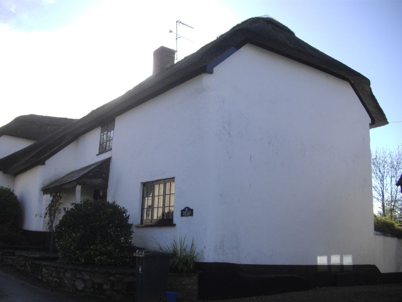
BROADHEMBURY BROADHEMBURY
SY 10 SW
5/48 The Old Colony formerly called
22.2.55 Glanville's Farmhouse
GV II
Former farmhouse. Late C16/early C17, late C20 renovations. Whitewashed rendered
cob and stone rubble; thatched roof with a plain ridge, hipped at left end, gabled at
right end; axial stack with a brick shaft, right end stack (shaft dismantled), stack
to the rear wing.
Plan: 3 room and through passage plan, unheated lower end to the left (west), hall
stack backing on to the passage and a formerly heated inner room. A series of
outshuts off the rear (north) wall provide a small buttery off the hall and service
rooms.
Exterior: 2 storeys. Asymmetrical 3 window south front, facing the former yard, with
a C20 front door to the passage to left of centre. To the right of the door 2 ground
floor windows retain late C16 or C17 moulded timber frames with C20 glazing, other
windows 2- and 3-light C20 timber casements with glazing bars. The rear (north)
elevation, facing the road, has a C19 or C20 plank rear door to the passage below a
slated pentice and 1 first floor 2-light and 1 ground floor 3-light C20 timberd
casement with glazing bars. To the left, a series of outshuts with catslide roofs.
Interior: The hall has a good open fireplace with chamfered Beerstone jambs a
chamfered timber lintel with mason's mitres and a bread oven. On the rear (north)
wall a good ovolo-moulded doorframe leads into the buttery outshut and, adjacent to
this, a C17 fitted dresser with 2 sets of cupboards and turned balusters survives in
the thickness of the wall. The hall/inner room partition has largely been removed,
the remains are oak studs formerly with a wattle infill with a blocked ovolo-moulded
doorframe. Only the chamfered timber lintel of the inner room fireplace survives.
Roof: One side-pegged jointed cruck truss survives, the apex is not smoke-blackened.
At the east end of an outstanding village characterized by cob and thatch.
Listing NGR: ST1026204713
External links are from the relevant listing authority and, where applicable, Wikidata. Wikidata IDs may be related buildings as well as this specific building. If you want to add or update a link, you will need to do so by editing the Wikidata entry.


Other nearby listed buildings
