Approximate Location Map
Large Map »
Latitude: 52.3349 / 52°20'5"N
Longitude: -2.059 / 2°3'32"W
OS Eastings: 396079
OS Northings: 270761
OS Grid: SO960707
Mapcode National: GBR 2FY.N7Q
Mapcode Global: VH9ZL.8KCX
Plus Code: 9C4V8WMR+XC
Entry Name: Sunday School
Listing Date: 1 November 1972
Grade: II
Source: Historic England
Source ID: 1099543
English Heritage Legacy ID: 155682
ID on this website: 101099543
Location: Bromsgrove, Worcestershire, B60
County: Worcestershire
District: Bromsgrove
Electoral Ward/Division: Bromsgrove Central
Parish: Non Civil Parish
Built-Up Area: Bromsgrove
Traditional County: Worcestershire
Lieutenancy Area (Ceremonial County): Worcestershire
Church of England Parish: Bromsgrove
Church of England Diocese: Worcester
Tagged with: Building
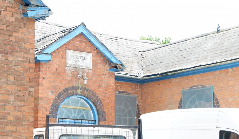
CHAPEL STREET
1.
909 Sunday School
SO 9670 NW 3/134
II
2.
Dated 1852. Red brick with engineering brick dressings. 1 storey. Two
gabled wings and porch forming E plan. Central door with fanlight. Tall
round arched windows with glazing bars. Slate roof.
Listing NGR: SO9607970761
External links are from the relevant listing authority and, where applicable, Wikidata. Wikidata IDs may be related buildings as well as this specific building. If you want to add or update a link, you will need to do so by editing the Wikidata entry.


Other nearby listed buildings
