Approximate Location Map
Large Map »
Latitude: 51.7536 / 51°45'13"N
Longitude: -0.354 / 0°21'14"W
OS Eastings: 513715
OS Northings: 207386
OS Grid: TL137073
Mapcode National: GBR H89.19Y
Mapcode Global: VHFS7.T670
Plus Code: 9C3XQJ3W+FC
Entry Name: 29, St Michaels Street
Listing Date: 27 August 1971
Grade: II
Source: Historic England
Source ID: 1103085
English Heritage Legacy ID: 163409
ID on this website: 101103085
Location: St. Albans, Hertfordshire, AL3
County: Hertfordshire
District: St. Albans
Electoral Ward/Division: Verulam
Parish: Non Civil Parish
Built-Up Area: St Albans
Traditional County: Hertfordshire
Lieutenancy Area (Ceremonial County): Hertfordshire
Church of England Parish: St Albans St Michael
Church of England Diocese: St.Albans
Tagged with: Building
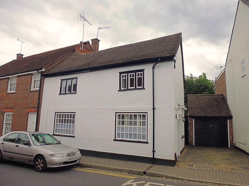
ST MICHAEL'S STREET
1. (East Side)
1582
No 29
TL 1307 SE 7/273
II
2.
C17 house of 2 storeys, 2 windows. 1st floor cement rendered, ground
floor brought forward in later brick. High pitched, tiled roof with moulded
eaves cornice. 1st floor 3-light casement windows, ground floor windows
replaced. Entrance, on return, has door of 6 fielded panels under reeded
frieze and bracketed cornice hood. Inside exposed beams and old plank
floors.
Listing NGR: TL1371507386
External links are from the relevant listing authority and, where applicable, Wikidata. Wikidata IDs may be related buildings as well as this specific building. If you want to add or update a link, you will need to do so by editing the Wikidata entry.


Other nearby listed buildings
