Approximate Location Map
Large Map »
Latitude: 50.7231 / 50°43'23"N
Longitude: -3.5324 / 3°31'56"W
OS Eastings: 291929
OS Northings: 92613
OS Grid: SX919926
Mapcode National: GBR P0.PZFZ
Mapcode Global: FRA 37H5.FN0
Plus Code: 9C2RPFF9+62
Entry Name: 194, High Street
Listing Date: 18 June 1974
Grade: II
Source: Historic England
Source ID: 1103902
English Heritage Legacy ID: 89233
ID on this website: 101103902
Location: Exeter, Devon, EX4
County: Devon
District: Exeter
Electoral Ward/Division: St David's
Parish: Non Civil Parish
Built-Up Area: Exeter
Traditional County: Devon
Lieutenancy Area (Ceremonial County): Devon
Church of England Parish: Central Exeter
Church of England Diocese: Exeter
Tagged with: Building
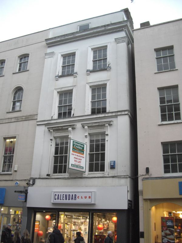
HIGH STREET
1.
1092
(North-west Side)
No 194
SX 9192 NE2/950
II GV
2.
C18 or earlier with an early C19 front. Timber-framed and rendered. 4 storeys,
2 windows, sashes with glazing bars and architrave surrounds. Pilastered front.
Dentil cornice, roof not visible. Of one build with Nos 193 and 194.
Nos 192 to 203 (consec) form a group.
Listing NGR: SX9192192613
External links are from the relevant listing authority and, where applicable, Wikidata. Wikidata IDs may be related buildings as well as this specific building. If you want to add or update a link, you will need to do so by editing the Wikidata entry.


Other nearby listed buildings
