Approximate Location Map
Large Map »
Latitude: 50.9143 / 50°54'51"N
Longitude: -1.2725 / 1°16'21"W
OS Eastings: 451237
OS Northings: 113008
OS Grid: SU512130
Mapcode National: GBR 87V.P29
Mapcode Global: FRA 867P.D2G
Plus Code: 9C2WWP7G+PX
Entry Name: 31, High Street
Listing Date: 14 February 1983
Grade: II
Source: Historic England
Source ID: 1112072
English Heritage Legacy ID: 354876
ID on this website: 101112072
Location: Botley, Eastleigh, Hampshire, SO30
County: Hampshire
District: Eastleigh
Civil Parish: Botley
Built-Up Area: Hedge End
Traditional County: Hampshire
Lieutenancy Area (Ceremonial County): Hampshire
Church of England Parish: Botley All Saints
Church of England Diocese: Portsmouth
Tagged with: Building
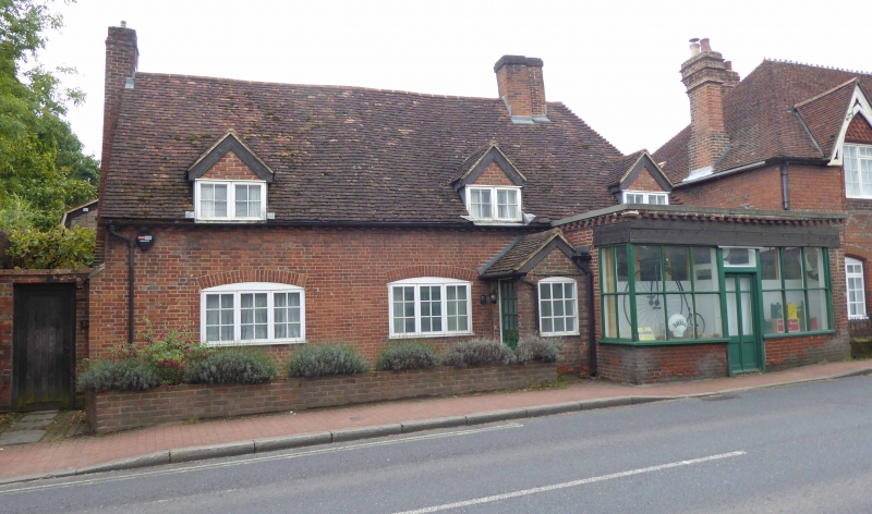
1.
5230 BOTLEY HIGH STREET
(south side)
No 31
SU 5112 NW 9/33
SU 5113 SW 9/33
II
2.
C18. Two storeys (including dormers with cills at eaves line). Red tile roof.
Hipped west, gabled east, with old chimney stacks; gabled dormers. Red brick
walling in Flemish bond, cambered openings. Casements. Simple doorcase east is
modern projecting shop front.
Listing NGR: SU5123313006
External links are from the relevant listing authority and, where applicable, Wikidata. Wikidata IDs may be related buildings as well as this specific building. If you want to add or update a link, you will need to do so by editing the Wikidata entry.


Other nearby listed buildings
