Approximate Location Map
Large Map »
Latitude: 51.4534 / 51°27'12"N
Longitude: -0.9747 / 0°58'28"W
OS Eastings: 471339
OS Northings: 173207
OS Grid: SU713732
Mapcode National: GBR QLG.5G
Mapcode Global: VHDWT.2Q2Q
Plus Code: 9C3XF23G+84
Entry Name: 17 Castle Street, front railings and mounting block
Listing Date: 22 March 1957
Last Amended: 21 October 2022
Grade: II*
Source: Historic England
Source ID: 1113413
English Heritage Legacy ID: 38792
ID on this website: 101113413
Location: Reading, Berkshire, RG1
County: Reading
Electoral Ward/Division: Abbey
Parish: Non Civil Parish
Built-Up Area: Reading
Traditional County: Berkshire
Lieutenancy Area (Ceremonial County): Berkshire
Church of England Parish: Reading St Giles
Church of England Diocese: Oxford
Tagged with: Building
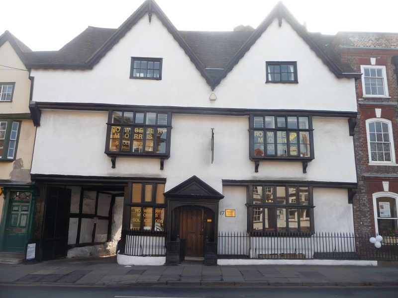
C16 house with later alterations and rear extensions. In use as an office from the later C20.
House of the C16, extended to the rear, probably in the C17 or C18, and again in the C19. In use as an office from the later C20.
MATERIALS: timber framed with rendered stucco to the front elevation and exposed red-orange brick with occasional blue brick headers at the east elevation. Tiled roof.
PLAN: double-gabled, with off-centre entrance flanked by rooms, leading to a stair hall, and a rear wing.
EXTERIOR: the front range is of two bays over three storeys with the third floor in the attic; the two-bay rear wing has two storeys with a part-cellar. The mid-C19 extension to the wing, believed to have been a warehouse, has three bays and three storeys.
The gable roofs are tile-covered; on the rear pitch of the front range’s roof are five, C16 diamond-profile stacks, some with repaired brickwork. The principal front of the C16 range has oversailing first and second floors with moulded jetties on decorated, carved brackets. In general, the windows have been restored, and have modern casements but the frames are mainly original. At the ground floor is an off-centre modern door under a restored, panelled C17, timber porch with a moulded cornice and pediment on square posts, segmental-arched heads across openings and panelled timber guards to each side with an ornamental dog-gate. To each side are projecting, heavily-moulded, transomed and mullioned rectangular window frames of 14 lights to the west (right) and eight to the east (left). Further to the east is a vehicular entrance with C17, eight-panel, double yard doors with a 'porte batarde' and cobbled and paved carriage path. The entrance opening has structural bridging beams and box-framing apparent on the east side of the carriage opening. Box-framing is apparent on the east return of the front range.
At the first floor, there are two projecting casement windows of 21 lights with lightly-moulded, transomed and mullioned frames on small carved brackets. The windows on the second (attic) floor are small eight-light C18 Yorkshire sashes. The two gables have decorative cut bargeboards and central pierced finials.
The front range’s rear elevation is obscured by the rear wing, built of brick laid in both stretcher and Flemish bond with timber framing, but a modern door leads from the front range to stone steps with an early-C19 balustrade. A C19, first-floor, flat-roofed extension to the rear wing, with scalloped soffit, is supported on slender columns and oversails the stairs. It is of red-orange brick laid in Flemish bond with blue brick headers, topped by weatherboarding, with eight-light casement windows. The columns are placed on either side of a mounting block (see subsidiary features below).
Further south at the ground floor of the rear wing is a projecting canted bay with horned, two-over-two sash windows over a segmental opening into the cellar. On the first floor is exposed vestigial box-framing with a replacement corner post and mid rail and two small sash windows. A former warehouse building is attached to the south, constructed of brick laid in Flemish bond, with a pitched, tile-covered roof with ridge stacks. All openings have segmental heads. At the ground floor is a timber panelled door; the flanking windows and those on the floors above are not of consistent form. At the south end, a metal stair leads to a door at the first floor. Metal tie rods have been inserted historically and between two windows at the second floor, there is a metal structure from which a sign may have been suspended.
INTERIOR: in general, lowered ceilings, modern partitions and finishes have obscured much of the historic interior throughout, but some exposed timber members can be observed including bridging beams, wall posts, mid-rails and tie beams. Most of the doors are C20, but some C19 doors and one C18 door were observed, in addition to some joinery.
There are areas of greater exposed historic fabric. The main entrance leads to a large stair hall through an asymmetric screen arcade with moulded cornice. A ramped open-well stair of about 1700 with fat turned balusters, ball newels and closed moulded strings rises to all floors. Some wall panelling to the stairwell remains; there are also some sections of a modern handrail attached to the wall.
At the ground floor, the front, west room retains an early-C17 coffered ceiling with decorative strapwork to the main, chamfered and stopped bridging beam and carved pendants at the junctions of the moulded joists. This room also has exposed, good quality, substantial pegged and jointed box-framing including a moulded mid-rail and possible door frame at the far west end of the front wall. There are wide timber floorboards.
In the attic rooms of the front range, the queen post roof trusses are exposed. The wall plate, double purlins, principal rafters, tie beams and box-framed cross walls are evident. An incised carving of a C16 or C17 shoe is found on a front wall post in the eastern attic room.
SUBSIDIARY FEATURES: to the front are early-C19 railings on a dwarf wall. The four-step, rendered mounting block is located beside the carriageway near to the rear entrance of the front range.
The first written record of Reading dates from the C9 when the name seems to have referred to a tribe, called Reada’s people. It is possible that there was a river port here during the Roman occupation, and by 1086 there was a thriving urban community, recorded in the Domesday Book. The early Anglo-Saxon settlement is believed to have been located in the Castle Street and St Mary’s area, which has St Mary’s Minster at its heart. A church was established here probably in the late C6 or early C7, north of the Holy Brook, important crossings over the River Kennet and the strategic crossroad of important routes from east to west and north to south. The term ‘minster’ was in use by the C10 denoting a church of importance by the time of Domesday.
Reading Abbey was founded in 1121, transforming Reading into a place of pilgrimage as well as an important trading and ecclesiastical centre with one of the biggest and richest monasteries in England. The foundation of the abbey had a direct impact on the St Mary’s area, relocating the focus of economic activity away from the early settlement to a new position east of the town’s historic core probably by the 1400s. The area to the west of St Mary’s was known as ‘olde street’ by about 1160. The strategic position of the crossroads remained, however, with the roads leading south to Southampton, east to London, west to Bath and north to the Thames crossing at Caversham. The Historic Environment Record for Berkshire (record number MRD 3925) states that Castle Street is documented from the mid-C13 and may commemorate a castle that overlooked the earlier settlement although archaeological evidence for a castle has yet to be found.
Number 17 Castle Street is believed to date from the C16, a period when the town’s population was rapidly growing as a result of its cloth trade; by 1611 the population had grown to over 5,000. John Speed's map published in 1611 shows a building on the location of number 17 and it is reasonable to assume that this represents the current building.
Number 17 was built as a high-status residence evident from its architectural quality and prominent position in the town, but its early history is not apparently documented. The Castle Brewery was probably founded in the yard behind the building in 1698; Dearing, Cliffe and Williams (2021) note that the brewery was sited opposite The Sun Inn, one of its three tied houses. The building's history appears to have been entwined with the brewery since at least the 1830s, when Thomas Rickford, one of the brewery's owners was in partnership with Charles Curry Beckham at 17 Castle Street. Rickford, a retired Royal Navy purser and brewer, was Mayor of Reading between 1840-1844.
In 1847 Thomas Hawkins acquired an interest in the brewery and leased 17 Castle Street as a house, followed by his son Hugh, and it remained in the family until the end of the century. In about the 1850s, William and Charles Blandy joined the brewery which became known as the Blandy, Hawkins & Co Castle Brewery.
Historic photos from about 1840-1849 indicate that the earliest front range is little changed externally, but the rear wing is a later addition probably of the C17 or C18, extended again in the C19 by a warehouse-type structure associated with the brewery. Access to the brewery complex was through the vehicular entrance between numbers 15 and 17 Castle Street, as indicated on the historic Ordnance Survey 1:2500 maps since the late C19. The OS maps and Goad plan of 1895 show the brewery buildings extending further south than the current rear boundary of the property, onto a site which was later subsumed into the enlarged H & G Simonds brewery and redeveloped in the later C20. In around 1920, H & G Simonds bought the brewery and closed the Castle Street site but may have retained an interest in the buildings fronting Castle Street.
By 1901,17 Castle Street was the home of Dr Percy Howse and was known as Lyndford House. A drawing of the building by Laurence Davies of 1923 indicates again that little external change has occurred. A sale catalogue of the same date describes it as a freehold Elizabethan residence with factory premises and outbuildings, the latter presumably the former brewery buildings, which were extant until at least 1931. It retained its use as a doctors' surgery into the later C20; the building is now (2022) in use as an office.
Pevsner, Bradley and Tyack (2010, p470-1) describe numbers 15 and 17 as 'fine three-storey, double-gabled C16 houses' and note the open-well baluster staircase of about 1700 in number 17. To the front of the building is a C17 restored wooden entrance porch. The railings are likely to be early C19. Some of the chimney stacks have repaired brickwork. The glazing on the ground and first floors was renewed in the 1990s but is sympathetic in design and set within historic frames. The interior has been remodelled to a degree but the early plan-form is discernible and distinctive historic features, such as the stairs, remain.
The rear boundary wall between 15 and 17 Castle Street retains some narrow brickwork which may be early in date, but the wall has been patched over the years and substantially repaired in the C21 (the wall is not included in the listing).
17 Castle Street, Reading, is listed at Grade II* for the following principal reasons:
Architectural interest:
* as a prominent, high-status urban vernacular building of the C16 and later, with finely proportioned, jettied double-gables and chimney stacks, and accomplished decorative treatment at the façade. The C17 porch and double-yard doors with ‘porte batarde’ are distinctive additions;
* the interior retains a significant proportion of good quality early timber framing, particularly evident at the ground floor and attic levels where the incised shoe on a timber post is a rare graffito. The C17 coffered ceiling in the ground floor west room and the fine stairs of about 1700 add greatly to the overall significance of the building.
Historic interest:
* the long history and form of the building demonstrate the commercial and domestic occupation of English historic towns from the C16 onward which, amplified by its documented history, adds to the building’s more than special national interest.
Group value:
* the building has a degree of shared history, through the association with the Castle Brewery, with the C17 Sun Public House on the opposite side of Castle Street, listed at Grade II (NHLE entry 1321964), and demonstrable group value through the co-location of diverse listed buildings in close proximity, notably the neighbouring 15 and 19 Castle Street, both listed at Grade II* (NHLE entries 1303734 and 1113414).
External links are from the relevant listing authority and, where applicable, Wikidata. Wikidata IDs may be related buildings as well as this specific building. If you want to add or update a link, you will need to do so by editing the Wikidata entry.


Other nearby listed buildings
