Approximate Location Map
Large Map »
Latitude: 51.4533 / 51°27'11"N
Longitude: -0.9748 / 0°58'29"W
OS Eastings: 471332
OS Northings: 173195
OS Grid: SU713731
Mapcode National: GBR QLG.4H
Mapcode Global: VHDWT.2Q0T
Plus Code: 9C3XF23G+83
Entry Name: 19 Castle Street and associated front railings
Listing Date: 22 March 1957
Last Amended: 28 June 2022
Grade: II*
Source: Historic England
Source ID: 1113414
English Heritage Legacy ID: 38793
ID on this website: 101113414
Location: Reading, Berkshire, RG1
County: Reading
Electoral Ward/Division: Abbey
Parish: Non Civil Parish
Built-Up Area: Reading
Traditional County: Berkshire
Lieutenancy Area (Ceremonial County): Berkshire
Church of England Parish: Reading St Giles
Church of England Diocese: Oxford
Tagged with: Building
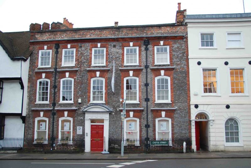
Former town house. Built in the early C18 with late-C18 or early-C19 additions to the rear. Linked to number 21 Castle Street above the ground floor.
Former town house. Built in the early C18 with late-C18 or early-C19 additions to the rear. Linked to number 21 Castle Street above the ground floor.
MATERIALS: silver-grey brick laid in header bond with red brick quoins and window surrounds. Clay tile roofs.
PLAN: three-storey plus basement, double-pile, main range fronting onto Castle Street with a two-storey plus attic extension to the south-west and a narrow single-storey plus attic and basement range to the south-east, extended in the C20. The ground floor has a central entrance passage with rooms either side giving onto a lobby providing access at the west end to the main staircase and the south-east range and, at the east end, to WCs and the large single room of the south-west extension. The first-floor staircase landing gives onto a lobby at the rear of the building with a large room at the north-east corner of the building and three other rooms at the front, partially sub-divided to create treatment rooms. The rear extension has a large single room reached via a short flight of stairs. A small corridor to the south of the treatment rooms connects with number 21. The layout of the second floor is similar with the rooms at the front of the building sub-divided into five treatment rooms all linked by a corridor, which also connects to number 21. A central lobby gives onto two rooms at the rear, divided by a stair giving access to a room in the attic of the rear extension. Beneath the south-east range is a long brick-vaulted cellar.
EXTERIOR: the principal (north) elevation onto Castle Street is symmetrical and of five bays with a parapet which has stone copings and a moulded brick cornice. The centrally placed entrance has a six-panel door with a plain transom replacing the original arched fanlight. The door surround has fluted Doric pilasters and Doric entablature and cornice capped by a segmental pediment. Fenestration is of timber sash windows, those on the ground floor having one-over-one plate glass panes, the first floor six-over-six glazing bars and the second floor three-over-six. The ground and first floor windows have deep segmental heads of gauged brick with fluted keystones and brick hoodmould. The second-floor windows have square-headed openings, also with fluted keystones. There are cast-iron rainwater goods with rounded hoppers on the interior of the two outer bays.
The rear (south) elevation is rendered with an ashlar effect and dominated by the full height, five-sided, bow of the rear extension. Fenestration, on the three principal faces, is of replacement timber sashes in plain, square-headed, openings, those on the first floor have six-over-six glazing bars while the ground floor ones are two-over-two apart from the larger central window which is eight-over-eight. The western return (to the alley between number 21) is blind with the western return having a window with paired four-over-four timber sashes on the ground floor and two, six-over-six, sash windows on the first floor. The roof slope above has a lead-covered, flat-roofed dormer with a pair of two-over-two timber casement windows. To the east of the extension is an oriel bay, with a six-over-six timber sash window, adjoining the sloping, slate-covered, roof of the start of the south-eastern range.
INTERIOR: the entrance hall has a deep moulded cornice and dado-height raised and fielded panelling. The eight-panel doors on either side of the entrance have eared moulded door surrounds with a cornice supported on fluted pilasters. The eastern ground-floor room has a dentil cornice, full height raised and fielded panelling and window shutters. The western room has been modernised but retains elements of the cornice. The south wall has a large elliptical arch with engaged fluted columns and a panelled soffit. At the south-west end of the hall is another elliptical arch but with fluted piers giving on the lobby to the large rear room in the western extension. This has a late-C18 or early-C19 patterned ceiling with a central pendant and modillion cornice. The windows retain their shutters and there is an eight-panel door. The closed string, open well staircase has tapered-column turned balusters, cushion-topped newel posts and dado panelling to the walls.
On the first floor, the two front (north) rooms have a deep moulded cornice, full-height panelling, window shutters and window seats. The western room has a corner fireplace with an eared surround, Rococo mantlepiece and cast-iron grate. The lobby to the south has dado-height panelling, some of its cornicing and an original door surround. The large rear room in the south-western extension, reached via a short flight of steps with the same type of balustrade as the main stair, has been modernised but retains its eared marble fire surround and window shutters. The rooms on the second floor are plain and have been largely modernised.
Beneath the south-eastern range, the long brick-vaulted cellar has modern kitchen fittings and tiled floor.
SUBSIDIARY FEATURES: the building is fronted on Castle Street by early-C19 spear-headed iron railings on a brick plinth enclosing areas of clay tiling either side of the entrance.
The first written record of Reading dates from the ninth century when the name seems to have referred to a tribe, called Reada’s people. It is possible that there was a river port here during the Roman occupation, and by 1086 there was a thriving urban community, as recorded in the Domesday Book. Reading Abbey was founded in 1121 and this transformed Reading into a place of pilgrimage as well as an important trading and ecclesiastical centre with one of the biggest and richest monasteries in England. By 1525 Reading was the largest town in Berkshire and the tenth-largest in England when measured in taxable wealth.
The Dissolution led to the monastic complex becoming a royal palace and by 1611 the town’s population had grown to over 5,000 as a result of its cloth trade. A number of the timber-framed houses from this period survive in Castle Street and Market Place.
During the C18 Reading became a prosperous market town and administrative centre, due to the development of the town’s waterways and road links. In 1723 the River Kennet was transformed into a canal, linking Reading to Newbury, further extended by the opening of the Kennet and Avon Canal in 1810, to create a route between Reading and the Bristol Channel. Turnpike roads were also improved, establishing major coaching routes from London to Oxford, the West Country and the southern coast. Iron works, brewing and malting caused the expansion of the town further west and in the older part of Reading, many earlier, timber-framed buildings were refaced in fashionable brick. A new town hall was built just northeast of the west end of Friar Street in 1786.
In the C19 the town expanded further; three separate railway companies ran routes through the town to London, causing a rapid increase in population (9,400 in 1801 to 21,500 in 1851 and over 70,000 by 1900) as well as the development of Reading’s famous Three B’s industries: beer (Simonds Brewery, 1785-2010), bulbs (Suttons Seeds, 1837-1976) and biscuits (Huntley and Palmers, 1822-1976), although all three industries have now left Reading or moved out from the centre of the town. Growth during this period was characterised by the proliferation of brick terraces, and Hardy referred to Reading as ‘Aldbrickham’ in his novel Jude the Obscure. In 1869 the town was confirmed as the county town for Berkshire and the extent of the borough was increased to the south in 1887 and again in 1911 to the north and west.
Reading is one of the largest urban areas in the UK without city status. The town centre was considerably changed between 1969 and the 1980s with the development of the Inner Distribution Road and also the opening of the M4 in 1971.
Castle Street originally formed part of the southernmost of two ancient routes (the other became Oxford Road) passing through the town from London to the West Country. John Speed’s map of Reading of 1610 shows the eastern part of Castle Street already fully developed on both sides and forming one of the principal streets of the town. By the C18, development extended as far as the junction with Tilehurst Road. This is shown on John Rocque’s Map of Berkshire (1761). Comprehensive development of the area around Castle Street began in the early C19, with some of the buildings shown on Rocque’s map seemingly replaced.
19 Castle Street was built in the early C18, probably as a high-status town house and replacing an earlier building on the site. A Sun Fire Insurance mark, number 467802, originally located in the pediment of the doorcase (present in the original List description but now removed) refers to insurance taken out in 1782 by the owner John Deane and tenant Frances Mitchell (widow). The building is first clearly shown on Charles Tomkins’ map of 1802. When street numbering was introduced, the building was originally numbered as 137 Castle Street and in the 1847 Street directory, it is shown to have been in use as a ladies’ school run by Mrs Harriett Cowderoy and Miss Martha Higham (described as a seminary in 1847, but Cowderoy and Higham’s Ladies Boarding School in 1852). The house appears in a photograph, dating from between 1840 and 1849, by the pioneering photographer William Henry Fox Talbot. Harriett Cowderoy's (nee Higham) husband, Benjamin, who she married in 1845, had briefly been Talbot's business manager from 1846-1847 and was involved with local politics before leaving for Australia in 1852.
By the time of the 1874 street directory, the building, numbered now as number 19 Castle Street and also known as Devonshire House, was occupied by John Old, a teacher of music. From the late 1880s until at least 1915 the building was run by the Young Women’s Christian Association (YWCA). The 1958 Goad Insurance map shows the building to have been in use, along with number 21, as the hotel and catering department for H & G Simonds, one of Reading’s major brewers, founded in 1785. It subsequently had a number of other commercial uses before being taken over by the College of Integrated Chinese Medicine in 1993. The college acquired number 21 Castle Street in 2003, once again linking the two buildings.
19 Castle Street, a former early-C18 town house with late-C18 or early-C19 additions, is listed at Grade II* for the following principal reasons:
Architectural interest:
* as an excellent example of an early-C18 former town house of considerable status with a well-proportioned and architecturally refined façade;
* for its surviving high-quality C18 internal fabric including elaborate door cases, main staircase, panelling, window shutters, and intricate plasterwork;
* for its use of the polychromatic brickwork, a noted feature of the architecture of Reading.
Historic interest:
* it is located within a significant historic townscape, illustrating the C18 change from timber-framed to brick houses along Castle Street, and making a notable contribution to its rich architectural character and historic evolution.
Group value:
* with the numerous listed buildings on Castle Street most notably with the adjoining 17 Castle Street (Grade II*) and 21 Castle Street (Grade II) and the Sun Inn (Grade II) opposite.
External links are from the relevant listing authority and, where applicable, Wikidata. Wikidata IDs may be related buildings as well as this specific building. If you want to add or update a link, you will need to do so by editing the Wikidata entry.


Other nearby listed buildings
