Approximate Location Map
Large Map »
Latitude: 51.4442 / 51°26'39"N
Longitude: 0.2218 / 0°13'18"E
OS Eastings: 554500
OS Northings: 174028
OS Grid: TQ545740
Mapcode National: GBR VH.LLJ
Mapcode Global: VHHNT.SYMS
Plus Code: 9F32C6VC+MP
Entry Name: 15, Overy Street
Listing Date: 25 September 1975
Grade: II
Source: Historic England
Source ID: 1116084
English Heritage Legacy ID: 172136
ID on this website: 101116084
Location: New Town, Dartford, Kent, DA1
County: Kent
District: Dartford
Electoral Ward/Division: Brent
Parish: Non Civil Parish
Built-Up Area: Bexley
Traditional County: Kent
Lieutenancy Area (Ceremonial County): Kent
Church of England Parish: Dartford Holy Trinity
Church of England Diocese: Rochester
Tagged with: Building
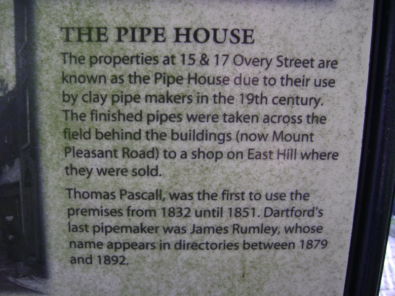
1. OVERY STREET
5274 (East Side)
No 15
TQ 5474 2/46
II GV
2.
Originally C18 and part of the same range as No 17, but refronted in the C19.
2 storeys. Old tiled mansard roof with 1 dormer. 3 cambered windows. Later
shopfront.
Nos 1 to 17 (odd) form a group.
Listing NGR: TQ5449774028
External links are from the relevant listing authority and, where applicable, Wikidata. Wikidata IDs may be related buildings as well as this specific building. If you want to add or update a link, you will need to do so by editing the Wikidata entry.


Other nearby listed buildings
