Approximate Location Map
Large Map »
Latitude: 51.4835 / 51°29'0"N
Longitude: -2.4846 / 2°29'4"W
OS Eastings: 366448
OS Northings: 176177
OS Grid: ST664761
Mapcode National: GBR JW.KMR0
Mapcode Global: VH88H.WZC3
Plus Code: 9C3VFGM8+C5
Entry Name: Church of St James
Listing Date: 24 April 1951
Grade: II*
Source: Historic England
Source ID: 1116192
English Heritage Legacy ID: 28809
ID on this website: 101116192
Location: St James's Church, Blackhorse, South Gloucestershire, BS16
County: South Gloucestershire
Parish: Non Civil Parish
Built-Up Area: Bristol
Traditional County: Gloucestershire
Lieutenancy Area (Ceremonial County): Gloucestershire
Church of England Parish: Mangotsfield
Church of England Diocese: Bristol
Tagged with: Church building
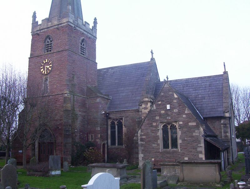
1.
5118 EX-MANGOTSFIELD UD ST JAMES'S STREET
Church of. St James
ST 67 NE 2/199 24.4.51.
II* GV
2.
Mediaeval Parish Church probably incorporating William de Putot's memorial
chapel of 1221-28. C13 with later mediaeval alterations and C19 rebuilding
and alterations. (James Foster of Bristol 1812, and Pope, Bindon and Clarke
1851). Built of pennant stone rubble with freestone dressings. Consists of
nave, chancel, north aisle, north chapel, vestry, south porch with tower over.
Three stage tower with embattled freestone parapet, pinnacles and octagonal
spire (raised 1851), square stair turret to north-east and diagonal buttresses
rising through one stage only. Below is C13 porch, inner doorway with deeply
undercut mouldings, detached shafts with waterholding bases, dog-tooth ornament
to capitals and trefoiled niche (restored) over the arch. Windows perpendicular
in style and mostly restored, some pointed and some square headed. West door
comparatively plain but with 2 flanking niches containing small shield-bearing
knights. Interior has nave arcade of 3 perpendicular arches. C15 font. C19
roof with angel corbels. Marble tablet to Edward Andrews, died 1758. In the
porch is a mediaeval wooden chest.
Listing NGR: ST6644876177
External links are from the relevant listing authority and, where applicable, Wikidata. Wikidata IDs may be related buildings as well as this specific building. If you want to add or update a link, you will need to do so by editing the Wikidata entry.


Other nearby listed buildings
