Approximate Location Map
Large Map »
Latitude: 51.2803 / 51°16'48"N
Longitude: 1.0778 / 1°4'39"E
OS Eastings: 614741
OS Northings: 157956
OS Grid: TR147579
Mapcode National: GBR TY2.P98
Mapcode Global: VHLGM.M2MW
Plus Code: 9F3373JH+44
Entry Name: 54, St Peter's Street
Listing Date: 7 September 1973
Grade: II
Source: Historic England
Source ID: 1116667
English Heritage Legacy ID: 442980
ID on this website: 101116667
Location: Canterbury, Kent, CT1
County: Kent
District: Canterbury
Electoral Ward/Division: Westgate
Parish: Non Civil Parish
Built-Up Area: Canterbury
Traditional County: Kent
Lieutenancy Area (Ceremonial County): Kent
Tagged with: Building
1.
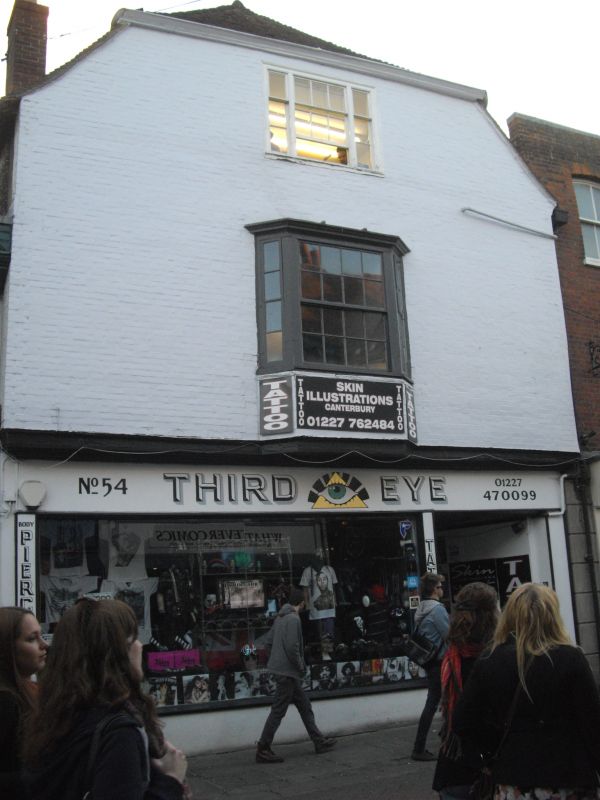
944 ST PETER'S STREET
No 54
TR 1457 NE 4/691
II GV
2.
A tall timber-framed building refaced with mathematical tiles, now painted,
with a trace of an overhang below the 1st floor. 3 storeys, Half hipped
old tiled roof. 1 triple sash with glazing bars intact. Later shop front,
Nos 49 to 60 (consec), Methodist Church and forecourt to Methodist Church
form a group.
Listing NGR: TR1473957952
External links are from the relevant listing authority and, where applicable, Wikidata. Wikidata IDs may be related buildings as well as this specific building. If you want to add or update a link, you will need to do so by editing the Wikidata entry.


Other nearby listed buildings
