Approximate Location Map
Large Map »
Latitude: 51.8924 / 51°53'32"N
Longitude: 0.8967 / 0°53'48"E
OS Eastings: 599421
OS Northings: 225504
OS Grid: TL994255
Mapcode National: GBR SN4.CJ1
Mapcode Global: VHKFZ.HPFN
Plus Code: 9F32VVRW+XM
Entry Name: The Roman Town Wall
Listing Date: 2 December 1971
Grade: I
Source: Historic England
Source ID: 1123664
English Heritage Legacy ID: 116851
ID on this website: 101123664
Location: Colchester, Essex, CO1
County: Essex
District: Colchester
Electoral Ward/Division: Castle
Parish: Non Civil Parish
Built-Up Area: Colchester
Traditional County: Essex
Lieutenancy Area (Ceremonial County): Essex
Church of England Parish: Colchester St Peter
Church of England Diocese: Chelmsford
Tagged with: City walls
This list entry was subject to a Minor Amendment on 11/05/2020
The Roman Town Wall
995
TL 9925 NW 1/1
TL 9925 NE 2/1
TL 9925 SW 4/1
TL 9925 SE 5/1
TM 0025 SW 6/1
TL 9924 NW 8/1
TM 02 NW 17/1
I
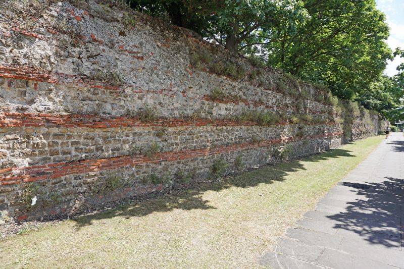
Probably of the late C3. Originally some 3,100 yards in length, forming a rectangle of about 1,000 yards east-west, and 510 yards north-south with rounded corners. Traceable throughout except in the south-west corner where it was much damaged by the 1648 siege. The three most important visible lengths are on Balkerne Hill on the west including the Balkerne Gate (qv), in the Castle Park on the north including the north-east Postern Gate and the great vaulted drain under, and the south-east corner in Priory Street. Built of layers of septaria, interspersed with four-fold course of brick, the lowest course going right through the wall, with a core of rubble and cement. Considerable lengths of the wall still reach a height of 15 ft, and it is on average 8 ft thick. The wall was strengthened in each corner and where it was met by the internal streets by an internal solid tower the base of one can be seen in the stretch on Balkerne Hill. The wall was extensively repaired during the reign of Richard II, 1389-1399 when it was strengthened by the addition of external semi-circular solid bastions, four of these remain in Priory Street. The wall was further considerably damaged in the 1648 siege, there is much brick patching in evidence in Priory Street, dating probably from the early C18.
There follows a detailed description of the wall's course and construction
commencing at the Balkerne Gate (qv) in the centre of the west side and
proceeding in a clockwise direction.
All measurements are approximate. All heights are of the outside face of the wall. The ground level on the inside is often considerably higher due to the bank of earth built as part of the fortifications.
A. Palkerne Gate to North Hill
455 yards, condition good.
Beginning at the Balkerne Gate (qv) the wall runs due north down the
east side of Balkerne Hill.
30 yards of Roman wall (for details of construction see previous notes), 12 ft high.
15 yards of medieval refacing, 12 ft high.
30 yards breach caused in the Civil War.
60 yards of Roman wall, 10 ft high, built on a bank. 40 yard breach filled by modern red brick wall.
Approximately 280 yards of Roman wall running to the rear of the old "Coach and Horses Inn" on North Hill, 10 ft high dropping to 8 ft, with considerable mediaeval repairs, particularly in the north-west angle.
B. North Hill to East Hill
1,100 yards, condition fragmentary. 80 yards of Roman wall considerably altered. Beginning between No 30 North Hill and No 1 Middleborough. 10 ft high dropping to 3 and 4 ft in yard of No 1. Behind Nos 2 and 4 Northgate Street (Northgate House) 3 ft high; then fading at the rear of Nos 8, 10 and 12 Northgate Street to the corner of Short Cut Road.
260 yards, no visible remains.
The row of houses, Nos 22A-32 (even) Northgate Street are built on the course of the wall, it then runs beside or under the road to the corner of Castle Park. 40 yards with a footpath on top of remains, only modern facing visible.
15 yards to the park gate, 3 ft high, Roman with much modern facing.
12 yd gap for park gate. 120 yards, Roman wall with much medieval and
later facing, 8-12 ft high.
5 yard gap for park gate.
90 yards of Roman wall with later facing, 10 to 12 ft high.
Duncan's Gate (postern) with drain under and remains of fallen tower.
35 yards, Roman, 8 to 10 ft high, running beside No 40 Castle Road.
Modern arch through to Castle Road.
100 yards to the north-east angle, Roman, 8 to 10 ft high, buttressed at angle.
From the north-east angle to East Hill the wall forms the garden wall to all the houses on the east side of Roman Road (Nos 55-15 odd, Nos 14-2 consec) except for Nos 23, 21, 19, 17, 15, 14, 13, 12 and 11 where it has been largely destroyed, Thus:- 70 yards, Roman with mediaeval facing, 8 to 10 ft high; along the Private Burial Ground and Nos 55, 53, 51 and 49 Roman Road.
30 yards, Roman, 6 ft high, behind Nos 47, 45, 43, 41 and 39 Roman Road.
60 yards behind Nos 37, 35, 33, 31, 29, 27 and 25 Roman Road where it has been virtually destroyed, at first a low wall of a few old stones with modern brick, then higher but completely rebuilt.
65 yards behind Nos 23, 21, 19, 17, 15, 14, 13, 12 and 11 Roman Road, no visible remains.
80 yards to East Hill, no significant remains behind Nos 10, 9, 8, 7, 6, 5, 4, 3, and 2 Roman Road and between Nos 89 and 90 East Hill.
C. From East Hill to Queen Street
490 yards, condition good.
80 yards, Roman, 12 ft high with mediaeval stone and modern brick facing along St James' Churchyard to the mediaeval Bastion (see previous notes). 70 yards, Roman with mediaeval stone repairs, 12 ft high, to smith-east angle and second medieval bastion.
50 yard breach (Civil War) rebuilt in C18 in red brick, 12 ft high.
200 yards to Bastion V. Roman with extension repairs. Height varies between 12 and 8 ft.
40 yards, Roman, 8 ft high, with red brick Bus Depot above.
25 yards gap through bus depot buildings.
25 yards to St Botolph's Street, between Nos 48 and 50, no visible remains.
D. Queen Street to Scheregate
285 yards to Scheregate, condition good.
60 yards to Bastion behind No 10 Short Wyre Street. Between Nos 1 and la St Botolph's Street and then behind Nos 1-10 (consec) Short Wyre Street. These houses have their rear walls built on the Roman wall, including the Bastion under No 10, but little remains of the original stonework.
225 yards from the Bastion to the Scheregate. Destroyed behind No 11 Short Wyre Street.
Roman, 6 to 8 ft high behind Nos 27-14 (consec) Eld Lane. Gap with modern filling behind No 13 Eld Lane.
Roman, 10 ft high to No 6A Eld Lane.
Breach between No 6A and No 5 Eld Lane. C18 red brick wall, 10 ft high.
Roman, 10 ft high, to Scheregate behind Nos 5-1 (consec) Eld Lane and between No 1 Eld Lane and No 2 Scheregate Steps. Incorporated in the buildings, partly destroyed and partly invisible.
Scheregate (qv) - medieval,
E. Scheregate to Head Street
225 yards, fragmentary to Head Street,
Between No 3 Scheregate Step and No 6A Sir Isaac's Walk, no visible remains.
20 yards beneath the car park. 6 ft high, but mostly rebuilt, some stonework.
Visible stonework behind No 6 Eld Lane.
Bottom garden wall behind Nos 36 to 48 (consec) St John's Street, running under the southern side of Eld Lane. Very fragmentary.
Running through buildings to Head Street. No visible remains, probably quite destroyed.
F. Head Street to the Balkerne Gate
400 yds, fragmentary. Running at rear of Nos 3-33 Crouch Street, and Nos 2, 3, 4 and 5 Church Walk, the rear walls of the latter being built above the Roman wall. No visible remains, probably largely destroyed. 30 yards, 10 ft high, behind Nos 35, 36 and 37 Crouch Street forming garden wall of St Mary's Cottage, Church Walk.
South-west angle destroyed. 20 yards, Roman, 6 ft high, behind No 8 Balkerne Lane,
25 yard gap.
20 yards Roman to postern gate behind, 10 ft high, behind Nos 14, 15 and 17 Balkerne Lane, No 17 is built into the postern gate.
From the postern gate to the Balkerne Gate, 100 yds, Roman, 12 ft high, in good condition, running behind Nos 18 and Nos 25 to 31 (consecutive).
The following buildings are connected with, and have possible ownership of, various portions of the Roman Wall.
A. Buildings structurally connected with visible remains
Balkerne Lane
No 17
The Hole in the Wall Public House.
Church Walk
Nos 2, 3, 4 & 5.
Eld Lane
Nos 1, 1b, 1c, 2, 3, 4, 5, 6a, 7, 11, 17, 18, 20, 21, 22, 23, 24, 25,
26 and 27.
Middleborough
No 1
Northgate Street
Nos 2, 4, 10 and 12.
North Hill
Nos 30 and 31.
Queen Street
Eastern Counties Bus Depot.
Sir Isaac's Walk
No 6.
Short Wyre Street
Nos 4, 5, 6, 7, 8, 9 and 10.
B. Buildings with possible invisible remains incorporated in the foundations: nothing certain.
Crouch street.
Nos 5, 7, 9, 11, 13, 15, 17, 19, 25, 27, 31, 33 and 41.
East Hill
Nos 89 and 90
St Botolph's Street
Nos 1 and la.
Scheregate
Nos 2 and 3.
Short Wyre Street
Nos 1, 2, 3a, 3b and 11.
Sir Isaac's Walk
Nos 6a and 6b.
C. Buildings not directly connected with the wall but it forms part of the property boundary.
Balkerne Hill
Gilberd Lodge.
Balkerne Lane
Nos 8, 18, 25, 26, 27, 28, 29, 30 and 31.
Castle Road
No 40.
Crouch Street
Nos 35 and 37.
East Hill
Church of St James.
Nos 89 and 90.
Eld Lane
Nos 1a, 6, 8, 9, l0, 13, 14, 15 and 19.
High Street
Easthill House.
Queen street
Eastern Counties Bus Depot.
Roman Road
Nos 2, 3, 4, 5, 6, 7, 8, 9, 10, 25, 27, 29, 31, 33, 35, 37, 39, 41, 43, 45, 47, 49, 51, 53, 55 and the Private Burial Ground.
The following of the foregoing buildings are of merit in themselves, and can be found listed under their respective streets.
Balkerne Lane
No 17
The Hole in the Wall Public House.
Church Walk
St Mary's Cottage.
Crouch Street
Nos 17 and 19.
No 37.
East Hill
Church of St James.
No 89
Eld Lane
No 1
Nos 3 and 4
No 5.
High Street
Easthill House.
Middleborough
No 1.
Northgate Street
Nos 10 and 12.
Scheregate
No 2.
No 3.
Sir Issac's Walk
No 6a.
No 6b.
Listing NGR: TL9942125504
External links are from the relevant listing authority and, where applicable, Wikidata. Wikidata IDs may be related buildings as well as this specific building. If you want to add or update a link, you will need to do so by editing the Wikidata entry.


Other nearby listed buildings
