Approximate Location Map
Large Map »
Latitude: 51.6287 / 51°37'43"N
Longitude: -0.7488 / 0°44'55"W
OS Eastings: 486700
OS Northings: 192952
OS Grid: SU867929
Mapcode National: GBR D54.X2Y
Mapcode Global: VHDW4.YBZ8
Plus Code: 9C3XJ7H2+FF
Entry Name: 18, High Street
Listing Date: 28 June 1973
Grade: II
Source: Historic England
Source ID: 1125160
English Heritage Legacy ID: 46045
ID on this website: 101125160
Location: High Wycombe, Buckinghamshire, HP11
County: Buckinghamshire
Electoral Ward/Division: Abbey
Parish: Non Civil Parish
Built-Up Area: High Wycombe
Traditional County: Buckinghamshire
Lieutenancy Area (Ceremonial County): Buckinghamshire
Church of England Parish: High Wycombe All Saints
Church of England Diocese: Oxford
Tagged with: Building
1.
963
SU 8692 NE
1/267
HIGH STREET
(North Side)
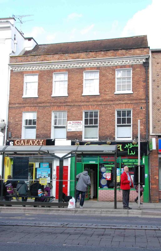
No 18
II
2.
C18 front of red brick, machine tiled roof. 3 storeys, dentil and moulded
cornice, parapet. Modern shops without cornices, 2nd floor band. 4 sashes
in reveals with flat arches, glazing bars except to lower halves of 1st
floor windows.
Listing NGR: SU8670092952
External links are from the relevant listing authority and, where applicable, Wikidata. Wikidata IDs may be related buildings as well as this specific building. If you want to add or update a link, you will need to do so by editing the Wikidata entry.


Other nearby listed buildings
