Approximate Location Map
Large Map »
Latitude: 50.3673 / 50°22'2"N
Longitude: -4.1588 / 4°9'31"W
OS Eastings: 246562
OS Northings: 54160
OS Grid: SX465541
Mapcode National: GBR R7M.4M
Mapcode Global: FRA 2852.9MJ
Plus Code: 9C2Q9R8R+WF
Entry Name: Nos. 10-19 Caroline Place including forecourt walls and railings
Listing Date: 1 May 1975
Last Amended: 17 September 2015
Grade: II
Source: Historic England
Source ID: 1130011
English Heritage Legacy ID: 473225
ID on this website: 101130011
Location: Stonehouse, Plymouth, Devon, PL1
County: City of Plymouth
Electoral Ward/Division: St Peter and the Waterfront
Parish: Non Civil Parish
Built-Up Area: Plymouth
Traditional County: Devon
Lieutenancy Area (Ceremonial County): Devon
Tagged with: Building
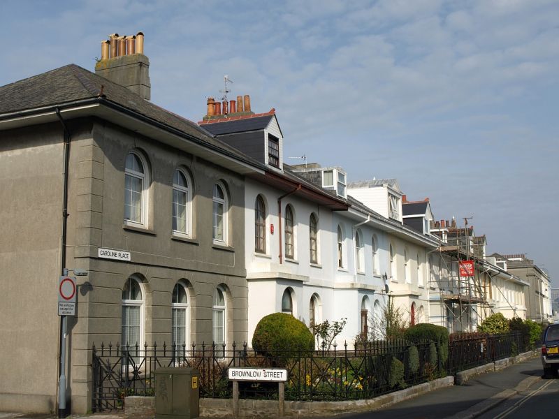
One of two planned terraces built circa 1835; rear wings were later added. The front half of No. 10 was rebuilt in 1948 following bomb damage suffered during the Second World War; the house was subdivided into two flats in the late-C20 and has now (2015) been returned to single occupancy.
One of two planned terraces built circa 1835; rear wings were later added. The front half of No. 10 was rebuilt in 1948 following bomb damage suffered during the Second World War; the house was subdivided into two flats in the late-C20 and has now (2015) been returned to single occupancy.
MATERIALS: the majority of the terrace is brick- and rubble-stone construction with stucco detailing (apart from Nos. 16 which has roughcast render). The roof is dry slate with deep eaves. There are brick stacks and clay pots at the end of each house, with further chimneys in some of the rear wings. No. 10 is brick, concrete-block and rubble-stone construction.
PLAN: double-depth plan with rear wings; the terrace is on an east-to-west axis.
EXTERIOR: the terrace buildings are each of two storeys and attic. Each house has three bays. Nos. 11-16 have porches on the left; those to Nos. 17 and 18 are on the right. No. 19 has a flat-roofed porch to the right-hand return. Some original hornless sashes survive; however, most have been replaced by late-C19 horned sashes or be either modern timber or uPVC replacements. The stucco detailing includes a rusticated ground floor, plat band and corner pilasters. Rear wings of various sizes extend to the north of each house. The roof is hipped at either end of the terrace and most of the houses have front and rear roof dormers in various styles.
The front part of No. 10 was rebuilt in 1948 with Portland-cement foundations and 2-inch cavity-brick walls. Stucco detailing, including a rusticated ground floor, plat band and a corner pilaster were added to compliment the rest of the terrace. The entrance with arched stucco surround is located on the left –hand return. The windows are early-C21 timber-sashes. The rear wing is rubble–stone to the lower-ground floor and includes concrete block within the floors above. There is also a former brick privy and store attached to the rear. The roofs are slate.
INTERIOR: Nos. 11-19 not inspected but likely to retain features of interest.
No. 10 was inspected in 2015. The front of the building dates entirely to the 1948 rebuild or later. The roof structure above the front range is a mid-C20 construction. The rear wing retains some C19 features including a rear stair and a lower-ground floor with a back-to-back range, a flagstone floor. The roof above the rear wing appears to also be mid-C20 and includes fragments of earlier heavily-charred beams which may relate to the bomb damage.
* Pursuant to s.1 (5A) of the Planning (Listed Buildings and Conservation Areas) Act 1990 (‘the Act’) it is declared that all internal building fabric within No. 10 dating to the 1948 rebuild and later is not of special architectural or historic interest.
SUBSIDIARY FEATURES: in front of the terrace is a low coped-rubble forecourt wall. The wall is topped by wrought-iron railings which were reinstated in 2003-6.
By the late-C18 the Stonehouse Peninsula had become a highly desirable residential area within Plymouth. This was in part due to the need to accommodate Naval and Dockyard Staff, and their families, following the establishment of military centres including the construction of the Royal Marine Barracks between 1781-83 (listed Grade II*) and the Royal Naval Dockyard between 1820s-1830s (listed Grade I). New and fashionable terraced housing appeared from the late C18 onwards. Caroline Place, built circa 1835 (it is referenced on a street plan of this date), was part of this continuing development. It comprises two planned terraces, Nos. 1-9 (1-4 were demolished in the C20, 5-9 listed at Grade II), and 10-19. The street was named after the second Earl of Edgcumbe’s daughter, Caroline.
The concentration of important military facilities in and around Stonehouse contributed to its intense bombardment during the Second World War. The peninsula did not suffer the same level of destruction; however, a list of bomb drop locations for Plymouth includes the junction of Caroline Place and Brownlow Street, where No. 10 Caroline Place stands. Although the building was not mentioned specifically in the list, an aerial photograph taken in 1947 shows the end terrace house with its roof and first floor entirely removed; the rear wing and rest of the terrace is intact. In 1948 permission was granted by the City of Plymouth for plans to rebuild the front part of No. 10 Caroline Place due to War Damage. In the late C20 the building was subdivided into flats. It was brought back into single occupancy in the early C21 and new timber sashes replaced uPVC windows.
Further post-war alterations to the terrace include the loss of a number of the original sash windows. In between 2003-2006, as part of the Stonehouse Townscape Heritage Initiative Phase 2, historic railings were reinstated along Caroline Place.
Nos. 10-19 Caroline Place is listed at Grade II for the following principal reasons:
* Architectural interest: as an elegant early-C19 terrace that is well articulated by neo-classical detailing and projecting porches;
* Historic interest: as part of the development Stonehouse as fashionable suburb which had increased in importance as a military centre;
* Group Value: it has strong group value with Nos. 5-9 Caroline Place (listed Grade II).
External links are from the relevant listing authority and, where applicable, Wikidata. Wikidata IDs may be related buildings as well as this specific building. If you want to add or update a link, you will need to do so by editing the Wikidata entry.


Other nearby listed buildings
