Approximate Location Map
Large Map »
Latitude: 53.6085 / 53°36'30"N
Longitude: -1.563 / 1°33'46"W
OS Eastings: 429008
OS Northings: 412531
OS Grid: SE290125
Mapcode National: GBR KVJQ.D5
Mapcode Global: WHCBB.YKVH
Plus Code: 9C5WJC5P+CQ
Entry Name: Overflow to Lower Lake, three weirs to east side of dam and pump house adjacent to middle weir, in Bretton Park
Listing Date: 6 May 1988
Last Amended: 21 June 1990
Grade: II
Source: Historic England
Source ID: 1135467
English Heritage Legacy ID: 342592
ID on this website: 101135467
Location: Wakefield, West Yorkshire, WF4
County: Wakefield
Civil Parish: West Bretton
Traditional County: Yorkshire
Lieutenancy Area (Ceremonial County): South Yorkshire
Church of England Parish: Woolley St Peter
Church of England Diocese: Leeds
Tagged with: Weir
This list entry was subject to a Minor Amendment on 27 September 2021 to update the name and address and to reformat the text to current standards
SE21SE
8/96
WEST BRETTON
PARK ROAD (south side, off)
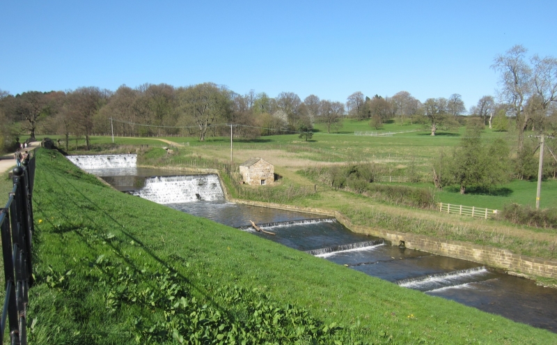
Overflow to Lower Lake, three weirs to east side of dam and pump house adjacent to middle weir, in Bretton Park.
GV
II
Overflow, weirs and pumphouse. The overflow and weirs probably c.1782 (date of Lower Lake), the pump house probably early C19. The overflow and weirs are lined in coursed squared stone with slight tooling or vermiculation. The pump house is of coursed square rubble with quoins and has a stone slate roof. The top weir forms the east end of The Cut which flows eastward to the north of the lakes. The overflow runs through a tunnel-vaulted skew-bridge to join the second weir in a 90x curve. The third weir is shallower. All the weirs are stepped and concave and the upper two weirs each have a drop of approximately 5 metres.
The pump house has an internal brick wall which farms a wheel-housing containing an iron-spoked water wheel of approximately 2 metres (6 feet) in diameter. The other chamber contains a crankshaft with two connecting rods to a pump. The goit driving the wheel appears to have been blocked. The pump is said to have been used to pump drinking water from a lower level up to the main house approximately 700 metres away.
Listing NGR: SE2900812531
External links are from the relevant listing authority and, where applicable, Wikidata. Wikidata IDs may be related buildings as well as this specific building. If you want to add or update a link, you will need to do so by editing the Wikidata entry.


Other nearby listed buildings
