Approximate Location Map
Large Map »
Latitude: 54.574 / 54°34'26"N
Longitude: -3.575 / 3°34'29"W
OS Eastings: 298284
OS Northings: 521009
OS Grid: NX982210
Mapcode National: GBR 3HGK.T3
Mapcode Global: WH5Z2.19X9
Plus Code: 9C6RHCFG+J2
Entry Name: Britton's Tomb to South of St Bridget's Chancel
Listing Date: 9 August 1984
Grade: II
Source: Historic England
Source ID: 1137260
English Heritage Legacy ID: 76146
ID on this website: 101137260
Location: Parton, Cumberland, Cumbria, CA28
County: Cumbria
District: Copeland
Civil Parish: Parton
Built-Up Area: Parton
Traditional County: Cumberland
Lieutenancy Area (Ceremonial County): Cumbria
Church of England Parish: Moresby St Bridget
Church of England Diocese: Carlisle
Tagged with: Architectural structure
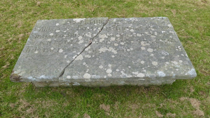
NX 92 SE PARTON
1/48 Brittons' tomb to
south of
St Bridget's Chancel
G.V. II
Table tomb. Inscribed and dated in Roman lettering: SEPTEMBER 17 1663 (or 8)
for William and Thomas Brittons (father and son) who were lost at sea on the
same ship. Sandstone blocks supporting flat top.
Listing NGR: NX9828421009
External links are from the relevant listing authority and, where applicable, Wikidata. Wikidata IDs may be related buildings as well as this specific building. If you want to add or update a link, you will need to do so by editing the Wikidata entry.


Other nearby listed buildings
