Approximate Location Map
Large Map »
Latitude: 52.1345 / 52°8'4"N
Longitude: -0.4662 / 0°27'58"W
OS Eastings: 505074
OS Northings: 249573
OS Grid: TL050495
Mapcode National: GBR G25.2YC
Mapcode Global: VHFQ7.VMW2
Plus Code: 9C4X4GMM+QG
Entry Name: Town Bridge over River Great Ouse
Listing Date: 6 June 1952
Last Amended: 12 April 2023
Grade: II
Source: Historic England
Source ID: 1138004
English Heritage Legacy ID: 35480
ID on this website: 101138004
Location: Bedford, Bedfordshire, MK40
County: Bedford
Electoral Ward/Division: Castle
Parish: Non Civil Parish
Built-Up Area: Bedford
Traditional County: Bedfordshire
Lieutenancy Area (Ceremonial County): Bedfordshire
Church of England Parish: Bedford St Paul
Church of England Diocese: St.Albans
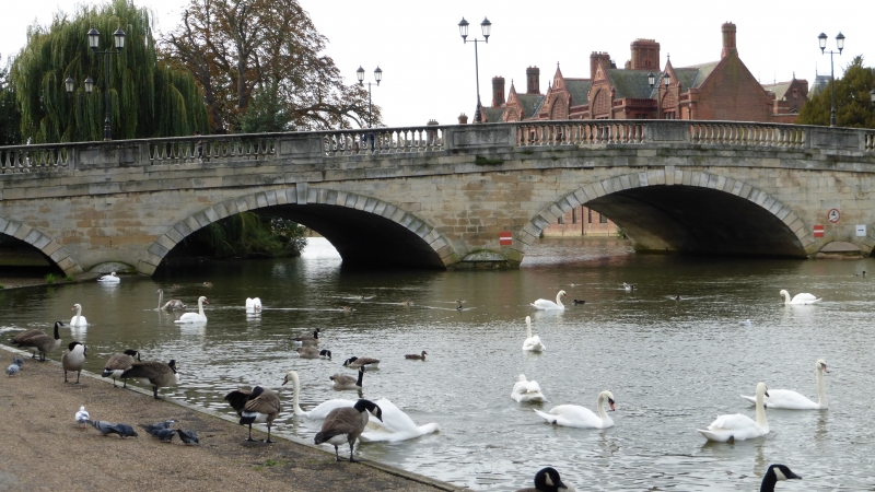
Town bridge over River Great Ouse, built between 1811 and 1813 to designs by John Wing and widened between 1938 and 1940.
Town bridge over River Great Ouse, built between 1811 and 1813 to designs by John Wing, and widened between 1938 and 1940.
Materials: the bridge is faced with ashlar sandstone, and arches faced with Portland stone.
Plan: the bridge is rectangular on plan and orientated north-south.
Description: the early-C19 bridge has five elliptical arches with rusticated voussoirs, and a balustraded parapet. The abutments and spandrels are faced in sandstone, and the voussoirs of the arches are faced in Portland stone. At the impost of each arch, the piers stand on semi-circular foundation blocks. The balustrade has a stone panel over each keystone and pier; a twin lamppost stands over each pier and bears the foundry mark of Baker of Bedford. A plaque commemorating the opening of the bridge in 1813 is fixed to the central panel on the west side of the carriageway. A plaque commemorating the removal of tolls from the bridge in 1835 is fixed to the central panel on the east side of the carriageway. A further plaque at the north end of the east wall commemorates the imprisonment of John Bunyan (1628-1688) in the gaol of the previous bridge. The intrados of each arch shows evidence of the widening of the bridge from 30 feet to 54 feet between 1938 and 1940.
Bedford lies in the shallow valley of the River Great Ouse, and from the Middle Saxon period, evidence appears for the beginnings of a settlement at ‘Beda’s ford’, a key river crossing point. The Middle Saxon core of Bedford developed on the north side of the river with an early street pattern (still recognisable) and was surrounded by a defensive ditch. In the C10 and C11, Bedford was important both as a trading centre, with coins minted in the town, and as the central burh of the shire. The town’s main north-south route, comprising what is now High Street to the north of the river and St Mary’s and St John’s Streets to the south of the river, was developed by this time. After 1066, Bedford became a stronghold of the new Norman regime and during the reign of William II, a motte and bailey castle was built in a strategic position on the north bank of the river and then rebuilt in stone. A period of unrest, however, led to a siege of the castle in 1224 and, when it fell, Henry III ordered it to be dismantled. Despite political struggles, the town experienced a period of consolidation during the Norman and Medieval periods, when local commerce flourished and religious houses and hospitals were founded. The population of the town was decimated by the Black Death in the C14, and a new river crossing at Great Barford undermined the local economy by drawing traffic and trade away from the town. There was little further growth and the town was largely contained within its Saxon framework, as can be seen from John Speed’s map of Bedford dated 1610.
The dissolution of the monasteries under Henry VIII dealt a further blow to the town’s prosperity but its fortunes began to revive with the receipt of letters patent from Edward VI, allowing the foundation of a grammar school. Bedford also benefitted from the River Navigation Act, which made the River Great Ouse navigable between Bedford and King’s Lynn (completed in 1689). The town became the headquarters of Cromwell’s army between 1646 and 1647 and the puritan influence established during the Civil War lived on after the Declaration of Indulgence in 1672 when the town became a centre for non-conformist preachers such as John Bunyan. Despite this prosperity, Bedford remained of modest size through to the end of the C18, as illustrated on Thomas Jefferys’ map of 1765. An Improvement Act in 1803 allowed for the erection of a new river bridge between 1811 and 1813 (widened in 1938), and clearance of the Market Square. Continuing prosperity in the early C19 was accompanied by modest growth, but by far the most dramatic expansion of Bedford followed the building of the Midland Railway in 1873, linking the town with London, and associated industrialisation. In the early years of the C20, some houses in the town centre were replaced by department stores, banks and cinemas to serve the expanding population; the Arcade was built and other properties in and around the centre were converted to shops and offices. The High Street is characterised by narrow three and four-storey frontages, with long buildings, closes and yards occupying medieval burgage plots to the rear, those on the eastern side of High Street being particularly long.
The former stone bridge on this site is said to have been constructed in 1224 using stone from the dismantled Bedford Castle. A chapel was built on the bridge by Simon de Beauchamp, but by 1311 this had fallen into disrepair and was replaced by a chapel dedicated to St Thomas. The bridge, which measured 330 feet in length and thirteen-and-half feet in width, was strengthened in the 1500s with stone from the demolished church of St Peter de Dunstable. The chapel on the bridge was converted to a town lock-up in 1589, but by 1661 it was in a poor state and not fit to hold prisoners; in 1663 it was washed away and was rebuilt in 1665. The bridge had two gatehouses, which were removed in 1765 as they hindered coach traffic across the bridge. Cole and Roper’s map of Bedford, published around 1801, shows the bridge in a poor state of repair, and the Improvement Act of 1803 called for the entire bridge to be rebuilt. A coloured engraving of the ‘East Side of Bedford Bridge’ by William Byrne and Thomas Hearne was published in 1806 and shows the ancient bridge from the southeast.
The new bridge was designed by architect and thrice former Mayor of Bedford John Wing (1756-1826) and built between 1811 and 1813. Wing came from a family of accomplished stonemasons and architects with a lease on the Totternhoe quarries, and collaborated with his father on the design and construction of Girtford bridge at Sandy, Bedfordshire (1783, listed at Grade II). Wing made many notable contributions within Bedford, including his designs of the Bedford House of Industry (1796, now Shires House), the new town prison (1801), and two detached houses at 46 and 50 Cardington Road (built around 1809 and 1817 respectively), each listed at Grade II. Wing’s bridge was 300 feet long and 30 feet wide, thus making it considerably wider than the original. Sandstone was sourced from Bramley Fall in Yorkshire and Portland stone for the arches. The bridge was completed at a cost of £15,137 with the help of public subscription; tolls were initially charged however this practice was abolished in 1835. A view of the bridge by JMW Turner in 1831 was published in the artist’s ‘Picturesque Views in England and Wales’. With the development of modern transport, the bridge needed to be widened to 54 feet between 1938 and 1940, and further strengthening work was undertaken in 1984 and 1992.
Bedford Town Bridge is listed at Grade II for the following principal reasons:
Architectural interest:
* for the architectural quality of this elegant bridge, constructed with quality materials and classical proportions;
* for its design by local architect John Wing (1756-1826), a number of whose designs of buildings in and around Bedford are included on the List at Grade II.
Historic interest:
* for the historic interest of this river crossing over the Great Ouse, believed to have been first constructed on this site in 1224;
* for the contribution the bridge makes to the evolution of the historic High Street and development of the town.
Group value:
* for its strong historic and functional group value with other listed buildings on High Street and St Mary’s Street.
External links are from the relevant listing authority and, where applicable, Wikidata. Wikidata IDs may be related buildings as well as this specific building. If you want to add or update a link, you will need to do so by editing the Wikidata entry.


Other nearby listed buildings
