Approximate Location Map
Large Map »
Latitude: 50.7191 / 50°43'8"N
Longitude: -1.8873 / 1°53'14"W
OS Eastings: 408052
OS Northings: 91059
OS Grid: SZ080910
Mapcode National: GBR X60.5Z
Mapcode Global: FRA 67Y5.LLG
Plus Code: 9C2WP497+J3
Entry Name: Corner House Hotel
Listing Date: 14 September 1984
Grade: II
Source: Historic England
Source ID: 1140117
English Heritage Legacy ID: 352113
ID on this website: 101140117
Location: West Cliff, Bournemouth, Christchurch and Poole, Dorset, BH2
County: Bournemouth, Christchurch and Poole
Parish: Non Civil Parish
Built-Up Area: Bournemouth
Traditional County: Hampshire
Lieutenancy Area (Ceremonial County): Dorset
Church of England Parish: Bournemouth St John with St Michael
Church of England Diocese: Winchester
Tagged with: Hotel
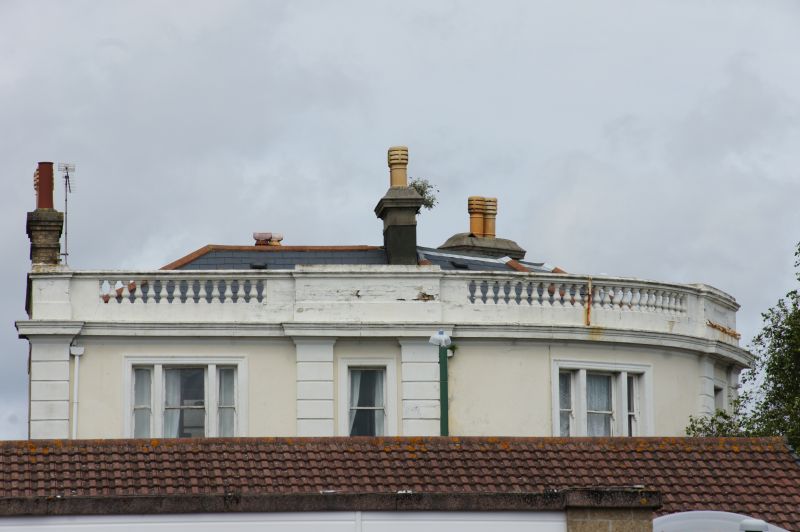
1. POOLE HILL
5186 (West Side)
Nos 1-3 (Corner House Hotel)
SZ 09 SE 13/99
II
2.
Hotel. c1855. Painted stucco with single pilaster strip with V-joints to outer ends,
to centre bay, and double pilaster strips framing second window unit from each outer
corner; roof concealed behind continuous parapet with balusters, and blockings at
centre and ends; roof probably slate. A corner building set to a fine curve covering
an acute-angled return. Three storeys, symmetrical, 7-windowed, alternatively
3-light and single-light plate glass sashes with rendered mullions and surrounds,
second floor under continuous cornice with projections at parapet blockings,over cill
band , and first floor windows over continuous plinth course including balusters
beneath windows at first floor the triple sashes have cornices on brackets and central
pediment: Central section has simple C20 plate glass enclosure in 3+3 bays and
resessed central glazed door. Simple, dignified, and little modified except for glass
entry area.
Listing NGR: SZ0805291059
External links are from the relevant listing authority and, where applicable, Wikidata. Wikidata IDs may be related buildings as well as this specific building. If you want to add or update a link, you will need to do so by editing the Wikidata entry.


Other nearby listed buildings
