Approximate Location Map
Large Map »
Latitude: 54.3197 / 54°19'10"N
Longitude: -2.7452 / 2°44'42"W
OS Eastings: 351625
OS Northings: 491826
OS Grid: SD516918
Mapcode National: GBR 9L8H.G8
Mapcode Global: WH82W.SPY9
Plus Code: 9C6V8793+VW
Entry Name: 28, 30, Milnthorpe Road
Listing Date: 30 January 1985
Grade: II
Source: Historic England
Source ID: 1145662
English Heritage Legacy ID: 75464
ID on this website: 101145662
Location: The Lound, Westmorland and Furness, Cumbria, LA9
County: Cumbria
District: South Lakeland
Civil Parish: Kendal
Built-Up Area: Kendal
Traditional County: Westmorland
Lieutenancy Area (Ceremonial County): Cumbria
Church of England Parish: Kendal Holy Trinity
Church of England Diocese: Carlisle
Tagged with: Building
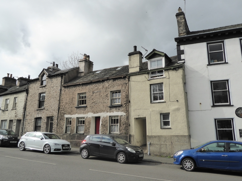
SD 59 SW (INSET) KENDAL MILNTHORPE ROAD
(West side)
2/122 Nos 28 & 30
G.V. II
House, now subdivided. C17 with later additions and alterations. Coursed
rubble on vermiculated plinth; battered. No 28 wet-dashed. Moulded cast-iron
gutter carried on dentils. Graduated slate roofs with rendered chimneys; dormer
to no 28, two skylights to no 30, which also has original stair wing and C19 (?)
outshut to rear. 2 storeys with attic. No 28, two bays. On left is passage to
rear, with C20 part-glazed door opening off north side; small sash to right.
Sash to 1st floor and dormer, narrow window to 1st floor north return. No 30,
four bays; stone steps up to recessed C20 plank door with sash to right and 2 to
left. Blocked fire window to 1st floor left with lintel to blocked 2-light
window visible between the two C19 sashes; 2 more blocked windows under eaves.
Original diamond-leaded casement survives in stair wing. Interior of no 30
retains plank and muntin partitions, chamfered beams, and flagged floors; spice
cupboard in ground floor front room (south) initialled and dated T & E W 1687.
Included partly for group value.
Listing NGR: SD5162591826
External links are from the relevant listing authority and, where applicable, Wikidata. Wikidata IDs may be related buildings as well as this specific building. If you want to add or update a link, you will need to do so by editing the Wikidata entry.


Other nearby listed buildings
