Approximate Location Map
Large Map »
Latitude: 51.4549 / 51°27'17"N
Longitude: -0.9733 / 0°58'23"W
OS Eastings: 471434
OS Northings: 173381
OS Grid: SU714733
Mapcode National: GBR QLF.GW
Mapcode Global: VHDWT.2PTJ
Plus Code: 9C3XF23G+XM
Entry Name: Church House, Reading
Listing Date: 22 March 1957
Last Amended: 12 January 2024
Grade: II
Source: Historic England
Source ID: 1156954
English Heritage Legacy ID: 39161
ID on this website: 101156954
Location: Reading, Berkshire, RG1
County: Reading
Electoral Ward/Division: Abbey
Parish: Non Civil Parish
Built-Up Area: Reading
Traditional County: Berkshire
Lieutenancy Area (Ceremonial County): Berkshire
Church of England Parish: Reading St Mary the Virgin
Church of England Diocese: Oxford
Tagged with: House
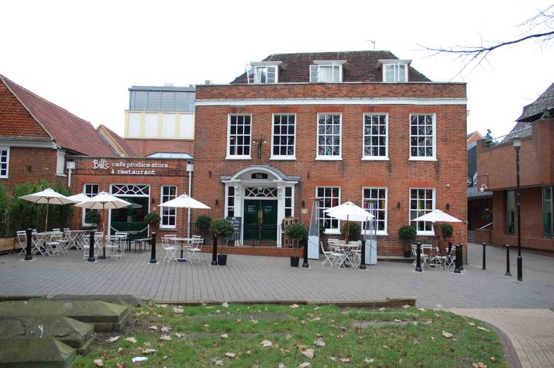
Early- to mid-C18 house, extended in the 1930s and converted to a restaurant in the 2010s.
Early to mid-C18 house, extended and altered in the 1930s and converted to a restaurant in the 2010s.
MATERIALS: red brick in Flemish bond, with a rendered east elevation, all under a clay tile roof.
PLAN: originally on a square, double-pile plan extended to the west side and now broadly rectangular.
EXTERIOR: the principal elevation faces south onto Chain Street and is two-storey plus a lit attic and is arranged across five bays. There is a three-bay, single-storey extension to the left side.
The original section has a wide entrance to the left side containing a pair of two-panel doors under a radiating fanlight with curved glazing bars. The C20 panelled doorcase has a pair of elaborately carved scroll brackets decorated with cupids and inverted acanthus, which support a segmental, open pedimented hood with panelled soffit. To either side, there are two-over-two sash windows with cornice above. To the right there are three, timber sash windows with six-over-six glazing, under gauged brickwork, arranged as a flat arch. To the first floor, there are five sash windows of a similar design, beneath a stucco string and coped, brick parapet. The roof is hipped with a central, square valley and has three, flat-roofed dormers with timber casements.
The east elevation has more irregular fenestration and a brick chimney stack projects from the south end. To the north, there is a three-over-three timber sash window on the ground floor and a nine-over-six timber sash on the first floor under a stucco string course. Adjoining to the north is a C19 extension. On the ground floor, it has a four-over-eight timber sash window and a carriage entrance with timber doors and a moulded stucco surround. On the first and second floors there are pairs of modern, two-pane, timber sashes. The roof over is pitched, with the rear slope partially levelled out. The original glazing bars and modillion cornice survive on the west front.
The 1930s extension is single-storey and has a wide central doorway with modern, glazed doors, flanked by a pair of narrow, timber sash windows with four-over-four glazing. The doorway and windows have flat-arch heads in gauged brickwork. Above, there is a brick string course and a coped, brick parapet. At either end of the elevation, there are moulded, iron rainwater goods, with raised lettering on the two hoppers reading ‘MDE’ (the western hopper) and ‘1931’ (the eastern hopper). The extension has a flat roof.
INTERIOR: this includes a staircase of around the 1740s with a wide, oak, moulded handrail, ramps and wide, turned balusters, which continue to the basement. There are two, pedimented doorcases to the staircase, one segmental, the other triangular. The ground floor room has an eared chimneypiece with pulvinated frieze to the front. The room above has a marble fireplace with an Adam-style surround with swaged frieze including cupids and a lion. The attic has a partition wall which retains part of a reused, moulded timber jetty.
The crossroads formed by the north-south route of St Mary’s Butts/Bridge Street and the east-west route of Gun Street/Castle Street is believed to be the centre of the original Saxon settlement at Reading, established sometime before the ninth century, with the lowest crossing point of the River Kennet lying a short distance away to the south.
Reading was well-established by the time of the Norman Conquest, and the Domesday Book (1086) records six mills and a large estate in the town. St Mary’s Church, which lies on the north-east corner of the crossroads and was mostly rebuilt in 1551-1555, was the town’s primary church until the establishment of Reading Abbey in the C12 and became so again following the dissolution in the late 1530s.
The church and churchyard were extensively restored and ‘improved’ during the late C19, with a row of buildings along the western side of the churchyard demolished to create the open relationship between the churchyard and St Mary’s Butts.
St Mary’s Church House was constructed in the early to mid-C18 and extended to the rear with the addition of a two-storey element containing a carriage entrance during the early to mid-C19. Sometime before 1879, the building became the premises of the Victoria Brewery and various brewery buildings were added to the north and west of the C18 house. The Victoria Brewery was bought out by the local Simonds Brewery in 1898 and the relevant Ordnance Survey map records the building as a dispensary.
In around 1931, the house was bought by the parish of the Church of St Mary, which lies immediately to the south (Reading Standard, 31 October 1931, p11). The house was extensively refurbished including a new, off-centre entrance with an elaborate, timber doorcase added to the south elevation, replacing the original central main entrance. In addition, a single-storey brick extension, reflecting the appearance of the original building, was added to the west side. By 1972 it was in use as a religious and vocational training centre (Reading Evening Post, 7 October 1972, p3). In around 2010, it was converted to restaurant use.
Church House, an early to mid-C18 house, extended in the 1930s and converted to a restaurant in the 2010s, is listed at Grade II for the following principal reasons:
Architectural interest:
* as an early to mid-C18 building which contributes to the character of an architecturally varied historic streetscape.
Historic interest:
* as part of the urban development of Reading’s ancient core.
Group value:
* the building is in close proximity to a large number of listed buildings and forms part of a strong historic grouping.
External links are from the relevant listing authority and, where applicable, Wikidata. Wikidata IDs may be related buildings as well as this specific building. If you want to add or update a link, you will need to do so by editing the Wikidata entry.


Other nearby listed buildings
