Approximate Location Map
Large Map »
Latitude: 54.7708 / 54°46'15"N
Longitude: -1.577 / 1°34'37"W
OS Eastings: 427308
OS Northings: 541851
OS Grid: NZ273418
Mapcode National: GBR KFF8.CK
Mapcode Global: WHC4Q.RB7Y
Plus Code: 9C6WQCCF+85
Entry Name: 11, South Bailey
Listing Date: 19 October 1962
Grade: II
Source: Historic England
Source ID: 1161384
English Heritage Legacy ID: 110488
ID on this website: 101161384
Location: Neville's Cross, County Durham, DH1
County: County Durham
Electoral Ward/Division: Elvet and Gilesgate
Parish: City of Durham
Built-Up Area: Durham
Traditional County: Durham
Lieutenancy Area (Ceremonial County): County Durham
Church of England Parish: Durham St Oswald
Church of England Diocese: Durham
Tagged with: Building
DURHAM AND FRAMWELLGATE SOUTH BAILEY
NZ 2741 NW (East side)
16/431 No. 11
19/10/62
GV II
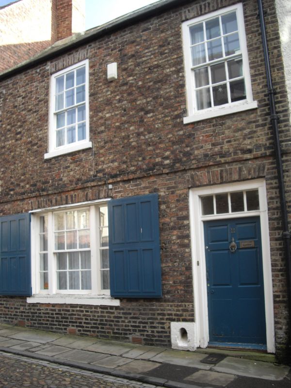
House. Early C18 with C17 rear parts. Later openings. Flemish bond brick
with painted ashlar dressings; Welsh slate roof with brick chimneys. 2
storeys, 2 bays. 6-panel door at right under 4-pane overlight and flat brick
arch; similar arches over wide tripartite ground-floor sash (with 6-panel
external shutters) and 2 first-floor sashes with glazing bars, all with
projecting stone sills. First floor level band. Steeply-pitched roof has 2
end chimneys, that at left renewed. Boot-scraper recess beside door. Twin
gabled rear wings, one possibly free-standing originally.
Listing NGR: NZ2730841851
External links are from the relevant listing authority and, where applicable, Wikidata. Wikidata IDs may be related buildings as well as this specific building. If you want to add or update a link, you will need to do so by editing the Wikidata entry.


Other nearby listed buildings
