Approximate Location Map
Large Map »
Latitude: 54.2138 / 54°12'49"N
Longitude: -1.6542 / 1°39'15"W
OS Eastings: 422645
OS Northings: 479835
OS Grid: SE226798
Mapcode National: GBR JMWQ.N7
Mapcode Global: WHC7D.KCG0
Plus Code: 9C6W687W+G8
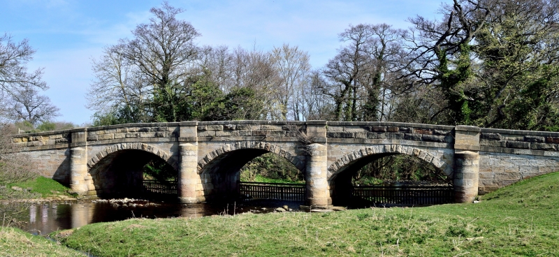
Entry Name: Low Burn Bridge
Listing Date: 9 August 1966
Grade: II
Source: Historic England
Source ID: 1166868
English Heritage Legacy ID: 325032
ID on this website: 101166868
Location: North Yorkshire, HG4
County: North Yorkshire
District: Harrogate
Civil Parish: Masham
Built-Up Area: Masham
Traditional County: Yorkshire
Lieutenancy Area (Ceremonial County): North Yorkshire
Tagged with: Bridge
SE 27 NW MASHAM GREWELTHORPE ROAD
6/42 Low Burn Bridge
9.8.66
- II
Bridge. 1715 with earlier origins. Ashlar stone. Three 7 metre segmental
arches with voussoirs. 4 semicircular cutwaters rising as pilaster
buttresses. Band. Coped parapet breaking forward and rising above
buttresses. Earlier bridge has 20 types of masons marks. Half the bridge
is in the parish of Swinton with Warthermarske.
Listing NGR: SE2264479844
External links are from the relevant listing authority and, where applicable, Wikidata. Wikidata IDs may be related buildings as well as this specific building. If you want to add or update a link, you will need to do so by editing the Wikidata entry.


Other nearby listed buildings
