Approximate Location Map
Large Map »
Latitude: 54.0479 / 54°2'52"N
Longitude: -2.8027 / 2°48'9"W
OS Eastings: 347542
OS Northings: 461625
OS Grid: SD475616
Mapcode National: GBR 8PWM.0P
Mapcode Global: WH846.XJK4
Plus Code: 9C6V25XW+5W
Entry Name: Penny's Almshouses Including Chapel and Screen Wall
Listing Date: 22 December 1953
Last Amended: 13 March 1995
Grade: II*
Source: Historic England
Source ID: 1195001
English Heritage Legacy ID: 383186
ID on this website: 101195001
Location: Lancaster, Lancashire, LA1
County: Lancashire
District: Lancaster
Electoral Ward/Division: Castle
Parish: Non Civil Parish
Built-Up Area: Lancaster
Traditional County: Lancashire
Lieutenancy Area (Ceremonial County): Lancashire
Church of England Parish: Lancaster St Mary with St John and St Anne
Church of England Diocese: Blackburn
Tagged with: Almshouse
LANCASTER
SD4761NE KING STREET
1685-1/7/152 (West side)
22/12/53 Penny's Almshouses, including chapel
and screen wall
(Formerly Listed as:
KING STREET
Penny's Hospital (Nos.1 to 12
consecutive))
(Formerly Listed as:
KING STREET
Chapel at Penny's Hospital)
(Formerly Listed as:
KING STREET
Entrance gateway at Penny's Hospital)
GV II*
Almshouses. 1720, altered early C20 and restored 1974. Built
by the executors of the will of William Penny. Sandstone
rubble boundary wall and ashlar entrance archway with ashlar
dressings, the dwellings mostly covered by roughcast render,
with green slate roofs. 2 parallel rectangular ranges at
right-angles to the street, each comprising 5 units with a 6th
added at the west end of both, forming a narrow courtyard
closed by a chapel at the west end and a screen wall with
entrance arch at the east end.
The entrance archway of 3 bays with rusticated quoins, shallow
Tuscan pilasters framing the centre, pulvinated frieze,
moulded cornice, and shaped gable with hollow-moulded coping
and ball finials. The central gateway is segmental-headed and
has a robust rusticated surround, and wrought-iron gates with
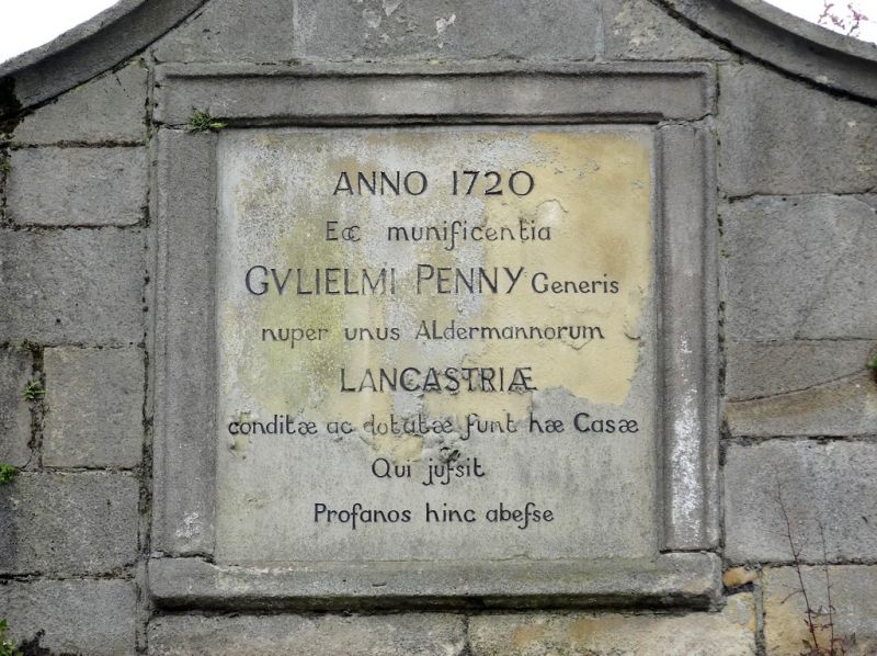
scrolled cresting; the original square lettered tablet in the
gable has been recently replaced with a modern one copying the
Latin inscription.
The houses are single-storeyed, each unit of one bay with a
window to the left of the door. The doorways have quoined
jambs and double lintels, and the large cross-windows have
slightly recessed flat-faced mullions and transoms, and leaded
glazing. The roofs have coped gables with ball finials on the
apex, and low rebuilt chimneys on the ridge. The added units
at the west end are in matching style but on a larger scale.
The courtyard has flagstone paving with gutters running along
the front of the dwellings crossed by flagstone bridges to the
doors.
The chapel at the west end presents a shaped gable facade of
coursed squared sandstone, with a keyed round-headed doorway
in the centre approached by 3 steps with simple curved
side-railings, a square tablet over the door inscribed FORGET
NOT/ THE CONGREGATION /OF THY POOR, and a square bellcote on
the apex of the gable, with a ball finial. The 2-bay side
walls have cross-windows, and the west end has a tripartite
round-headed window (but these are not visible from the
courtyard).
INTERIOR: the chapel has an oak dado of raised and fielded
panels, and a roof truss with tie-beam and sturdy turned
queen-posts. The altar table bears the date '1928', the
probable date of restoration.
HISTORY: William Penny (1646 - 1716) occupied various
positions on the Town Council and was three times Mayor of
Lancaster. When King Street was widened in the early C20 the
two almshouses nearest the road were demolished, the screen
wall rebuilt in its present position, the chapel shortened,
and two new almshouses built next to the chapel.
The chapel and entrance gateway were listed on 18.2.70.
Listing NGR: SD4754261625
External links are from the relevant listing authority and, where applicable, Wikidata. Wikidata IDs may be related buildings as well as this specific building. If you want to add or update a link, you will need to do so by editing the Wikidata entry.


Other nearby listed buildings
