Approximate Location Map
Large Map »
Latitude: 52.7457 / 52°44'44"N
Longitude: 0.4015 / 0°24'5"E
OS Eastings: 562198
OS Northings: 319157
OS Grid: TF621191
Mapcode National: GBR N3R.SD1
Mapcode Global: WHJP7.47FX
Plus Code: 9F42PCW2+7H
Entry Name: The South Gate, King's Lynn
Listing Date: 1 December 1951
Last Amended: 30 October 2020
Grade: I
Source: Historic England
Source ID: 1195304
English Heritage Legacy ID: 384203
Also known as: The South Gate
ID on this website: 101195304
Location: St James' End, King's Lynn and West Norfolk, Norfolk, PE30
County: Norfolk
District: King's Lynn and West Norfolk
Electoral Ward/Division: South and West Lynn
Parish: Non Civil Parish
Built-Up Area: King's Lynn
Traditional County: Norfolk
Lieutenancy Area (Ceremonial County): Norfolk
Tagged with: Gate
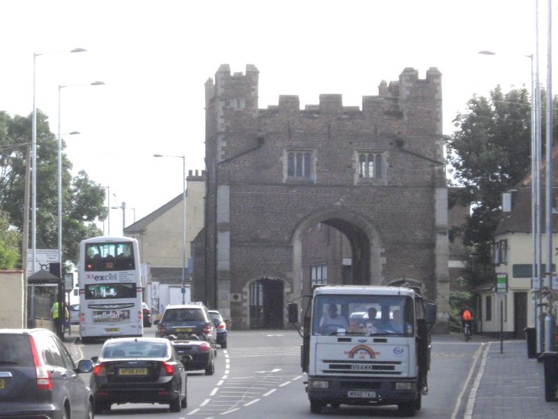
The South Gate was built as part of the town defences, and was the main entry to the town of King’s Lynn. Built in 1437 by Robert Hertanger in brick, with stone façade and dressings.
Gate tower. Constructed in 1437 by Robert Hertanger, with additional work by Nicholas and Thomas Harmer in 1520.
MATERIALS: brick with limestone dressings and façade. Lead roof.
PLAN: the gate is roughly rectangular with a central carriageway orientated north-south. The carriageway is flanked by a chamber on either side on both the ground and first floors. The second floor consists of a single room above the carriageway, running the entire width of the building. Access to the gate is provided by a door in the north wall of the west chamber.
FAÇADE: the south façade, faced with Ancaster and Barnack limestone, comprises a central arch, slightly offset to the west and flanked by two octagonal turrets. The arch is flanked by a doorway to each side, each topped with a four centred arch and set within a crenelated porch. The jambs of the central arch are unmoulded. A hood mould over the rise of the arch continues into a string course across the width of the façade. Two higher string courses continue around the entire building. The second floor has two three-light round-headed windows under square hoods. The western window is narrower, and is encroached upon by the corner turret. The dripstones are carved with heads, though these are now severely weathered. Round gun ports survive just below the string course and at second-floor level.
The north façade is similar, but in brick with ashlar dressings. The turrets on this façade are square, and there are two stone dressed buttresses perpendicular to the turrets. The side passage doorways have hood moulds rather than porches and only one gun port is visible.
The western and eastern façades are of brick with stone dressings. Each elevation has a single, square window located at ground-floor level. At first-floor level, the west façade has one two-light round-headed window under a square hood, whilst the east elevation has a single round-headed window. Both façades include a stone buttress concealing a latrine chute. The remains of the town wall are visible on the west façade and the east façade contains a blocked doorway.
INTERIOR: the central carriageway is constructed of brick, with a stone vault over the central void. The vault comprises a simple barrel vault, with five ribs. The corbels are decorated with a carved hare, a sleeping dog and two roses. Springing for a two bay stellar vault is visible, although only the south-west and south-east conoids survive.
The carriageway is flanked by a chamber on either side on both the ground and first floors, access to the gate is provided by a door in the north wall of the west chamber – the eastern chamber is gated at both ends. Two spiral stairways connect the building – the north-eastern stair is original, the north-western stair (reinstated between the ground and second floor only) is a modern replacement which is largely freestanding. Evidence of the original winder stair is visible in the adjacent brickwork. The stairways continued up to the lead roof where they emerge in square crenelated turrets which match the height of the octagonal towers.
The west ground-floor chamber is of brick, and contains a large fireplace under a depressed four-centred stone arch with hollow mouldings and pointed brick relieving arch above. There is a former bread oven on the left hand side of the fireplace. To the right of the fireplace is a lavabo (basin) with water outlets to outside. A raised wooden floor has been inserted on the south side of the room. The first-floor room contains a latrine opening into the buttress on the external wall, and there are three circular gun-ports in splayed recesses. The north jamb of the latrine doorway is carved with a small graffito or mason’s mark.
The east ground-floor chamber contains the remains of a large fireplace on the eastern internal wall, and is flagged. The first-floor chamber contains a fireplace in its eastern wall. As with the west first-floor chamber, it contains a latrine opening into the buttress on the external wall, and there are three circular gun-ports in splayed recesses. The south jamb of the latrine doorway is carved with a small graffito or mason’s mark.
The second storey chamber is of brick, and contains two brick fireplaces, one with a false three-centred arch under a pointed relieving arch and the other with a segmental arch over. A large blind arch, possibly once occupied by a portcullis, occupies the south wall (although the arch is too low for a portcullis to have functioned effectively). The chamber is not ceiled, revealing the roof timbers and two iron ties.
The settlement that ultimately became King’s Lynn is first referred to in the Domesday book as Lun (or Lena), and comprised a number of saltworkings. The bishop of Thetford (later Norwich), Bishop Herbert de Losinga, established a priory at Lun in 1090, and granted a charter for a market in 1101. Rapid expansion from the C12 onwards required an extension of the town, and Bishop William Turbe laid out a new settlement north of the Purfleet from around 1145. Both settlements were united under a royal charter in 1204, the united town being named Bishop’s Lynn. The town became one of England’s busiest ports, serving the Ouse and its tributaries, exporting wool and cloth, and importing wine, timber and luxury goods, and was a kontor (trading post) for the Hanseatic League. When Henry VIII dissolved the monasteries in 1536-1537, the town and manor became royal property, and Bishop’s Lynn was renamed King’s Lynn or Lynn Regis.
The defences of King’s Lynn were constructed in the C13, and linked the Fishers Fleet in the north with the river Nar to the south. Initially the gates to the town were guarded by wooden towers, or ‘bretasks’. The southern tower was certainly in place by 1325, as the Leet Rolls for that year record the area around the town responsible for its upkeep. The tower was repaired in 1359, and the whole structure was replaced between 1359 and 1377 by a stone built structure. The gate was repaired in 1416 using waste stone from the repair of St Nicholas’ Chapel, and either fell down or was demolished 20 years later.
The current gate was built in 1437 by Robert Hertanger, and used the base of the walls of the earlier gate as footings. Robert Hertanger, from Barfreston in Kent, was a London-based mason, and had previously worked on London Bridge. Hertanger went bankrupt during the building of the gate, and it was finished by another (unnamed) mason some time after 1439. Further works were carried out to the gate in 1520 by two masons named Nicholas and Thomas Harmer. Both are described as freemasons, but the extent of the work carried out and its relationship to the structure built by Hertanger is not clear. Nicholas and Thomas Harmer may have been brothers, or father and son. They are described as being from East Dereham and Borewell (either Burwell, Cambridgeshire or Bunwell, Norfolk), although these may be descriptions of their most recent places of work, rather than their place of origin.
The gate was occupied by a gatekeeper from at least 1602 (and probably earlier, as domestic facilities are built into the gate), and many lived in the gate itself. The upper chamber of the gate has been interpreted as part of their quarters, a civic function room and as the location of a mechanism for a portcullis. As the portcullis arch is too small to allow a portcullis to function, this last interpretation is unlikely.
At the advent of the Civil War, the mayor ordered that the bridge to the south of the South Gate be converted to a drawbridge. There is no evidence that these works were undertaken. On 13 August 1643, Sir Hamon L’Estrange established a Royalist stronghold in the town. The Earl of Manchester laid siege to the town on 28 August 1643 and bombarded it until it surrendered on 16 September 1643. The new governor, Captain Valentine Wauden, rebuilt the defences of the town. The South Gate was not damaged in the siege, but after the surrender of the town it was fortified by the construction of a bastion to the south of the bridge.
In 1721 the Corporation abolished tolls for entering and exiting the gate, and in 1741 abolished the post of gate keeper. The Jacobite invasion of England in 1745 caused the Mayor and Corporation to personally attempt to renovate the defences at the South Gate. However, the Jacobite forces (then at Derby) withdrew before the renovation works were finished. The gates were removed in 1795.
London Road, immediately to the north of the South Gate, was laid out and constructed between 1800 and 1804, providing a direct route from the South Gate into the centre of King’s Lynn. In 1817, a passageway was knocked through the east chamber of the gate, with a second passage being installed in the west chamber in 1841 (resulting in the removal of the western staircase). Two buttress walls which had flanked the central carriageway as it emerged from the south portal were removed and a footbridge to the west chamber was added at the same time. Internally, the chambers were plastered over, concealing the internal features.
In 1899 the road was widened, installing a second carriageway passing to the east of the gate. The bridge was widened at the same time. As this left the east chamber isolated in the centre of the road, it was closed off.
In the C20, the gatehouse was largely left untouched. The Friars Fleet, immediately to the south, was drained. The gatehouse was reroofed in 1966. The Gate was renovated between 1982 and 1985, which included a small archaeological excavation within the west chamber. The renovation works comprised the removal of the 1966 roof and the restoration of the medieval roof beneath it; the strengthening of the southern turrets with galvanised restraining bars; replacement of some windows; renovation of the stone and brickwork; removal of a C19 wall in front of the fireplace and lavabo in the ground floor western chamber; and the re-insertion of timber floors and the lost newel staircase in the western chamber.
The South Gate of King’s Lynn is listed at Grade I for the following principal reasons:
Architectural interest:
* as a remarkably complete and well preserved example of C15 urban defensive architecture;
* for its surviving features, including early gun loops;
* for the visible differences between the planned and finished structure, such as the portcullis slot and incomplete stellar vault.
Historic interest:
* for the site’s long documented history as the main entrance to the town from the south;
* as a good example of an early brick defensive structure.
Group value:
* the South Gate has strong group value with the scheduled archaeological deposits underneath the listed structure.
External links are from the relevant listing authority and, where applicable, Wikidata. Wikidata IDs may be related buildings as well as this specific building. If you want to add or update a link, you will need to do so by editing the Wikidata entry.


Other nearby listed buildings
