Approximate Location Map
Large Map »
Latitude: 52.7506 / 52°45'2"N
Longitude: 0.394 / 0°23'38"E
OS Eastings: 561678
OS Northings: 319687
OS Grid: TF616196
Mapcode National: GBR N3Q.JG1
Mapcode Global: WHJP7.04X4
Plus Code: 9F42Q92V+6J
Entry Name: Sommerfeld and Thomas Warehouse
Listing Date: 1 December 1951
Last Amended: 14 January 2020
Grade: II
Source: Historic England
Source ID: 1195401
English Heritage Legacy ID: 384322
ID on this website: 101195401
Location: King's Lynn, King's Lynn and West Norfolk, Norfolk, PE30
County: Norfolk
District: King's Lynn and West Norfolk
Electoral Ward/Division: St Margarets with St Nicholas
Parish: Non Civil Parish
Built-Up Area: King's Lynn
Traditional County: Norfolk
Lieutenancy Area (Ceremonial County): Norfolk
Tagged with: Architectural structure Former warehouse
A late-C18 warehouse which is the sole surviving element of an extensive grain storage and processing complex on King's Lynn's historic waterfront.
A waterfront warehouse dating to the mid-C18 and owned by a prominent Kings Lynn brewing family, subsequently altered and extended in the C19 and mid-C20.
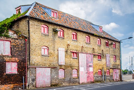
MATERIALS: the warehouse is built of buff brick with stone sills to window openings, and has a pantiled roof with lead-covered hips.
PLAN: the warehouse is linear in form, rear ranges having been demolished by 1950.
EXTERIOR: the building is a symmetrical design of seven bays and three storeys and attic. The principal central entrance rises through two storeys, with a segmental arched head now partially obscured by C20 suspended sliding door gear. The ground floor has two single gauged brick segmental arch-headed openings with shallow stone cills to each side of the entrance, and beyond them, sliding double doors to each of the end bays. At first-floor level are single taking-in doorways to bays two and six, the remaining bays each with a single-light window opening. The second floor has a single-light opening to each bay, detailed as the openings below. The roof structure incorporates two wedge dormers to the front slope and one dormer to each of the hip slopes. The small window opening have shuttered two-light wooden frames. The rear elevation is much altered with rendered walling, and with both enlarged original openings and additional ones. The south end of the building carries the scar of a former attached building.
INTERIOR: the interior of the building is characterised by massive bridging beams, carried on the front and rear walls, which support substantial closely-spaced joists. Many of the beams are supported mid-span with substantial square posts. The warehouse floors are pierced in the central bays by single hoist door openings with hinged doors opening upwards. In the bay to the south of the entrance bay are simple straight stair flights to each floor, access at ground-floor level by a vertical ladder fixed to the rear wall. At ground-floor level, the interior to the north of the entrance bay has been altered to provide office and toilet facilities, all now derelict. The first, second and attic floors are open throughout. The roof structure is formed of substantial rafters with two tiers of staggered purlins carried on principal rafters arranged three to each bay. There are collar timbers to each pair of principal rafters, those to the central bay supporting the hoist wheel and its cradle located above the hinged hoist doors.
King’s Lynn, first called Bishop’s Lynn, was founded in 1095 by Bishop Herbert de Losinga, who in the previous year had transferred the see from Thetford to Norwich. There was already an existing settlement which appears to have been based around a salt-water lagoon, or series of inlets, with its centre round the present All Saints Church. Losinga’s town developed to the north of this, between All Saints Church and Saturday Market Place where St Margaret’s Church and Priory were established from Norwich around 1100. Rapid expansion from the C12 onwards required an extension of the town, and Bishop William Turbe laid out a new settlement north of the Purfleet from around 1145, with its market at Tuesday Market Place and the Chapel of St Nicholas as a chapel of ease to St Margaret’s. Both settlements were united under a royal charter in 1204, the united town being named Bishop’s Lynn. Until the early C13, the Great Ouse emptied via the Wellstream at Wisbech, however following floods in the C13, the river was redirected to join the Wash at Bishop’s Lynn. The town became one of England’s busiest ports, serving the Ouse and its tributaries, exporting wool and cloth, and importing wine, timber and luxury goods, being adopted as a member of the original medieval Hanseatic League. This extremely influential trading association linked a group of towns around the Baltic and the North Seas, and played an important role in the prosperity and development of Bishop’s Lynn as a national port, which by the C14, was ranked as the third port of England (after London and Southampton).
Losinga’s town round the Saturday Market was protected from the river immediately to its west by the ‘great bank’, an earthwork which ran along the present line of Nelson Street, St Margaret’s Place and Queen Street. By about 1500 the river had moved approximately 50m west and was consolidated another 45m by the new South Quay in 1855. The period of development of the area between the Millfleet and Purfleet can therefore be identified, as well as building types and plans. The generous-sized plots are reflected in the surviving buildings dating from the C14 to the C17, which surround open courtyards. To the north, on Bishop Turbe’s ‘newe lande’, much the same pattern emerges: originally the west side of Tuesday Market Place was washed by the river, with King Street forming the line of the bank. The west side of King Street was built upon in the C13, with narrow plots, elongating in stages until river movement ceased in the C17. As land became available, warehouses were built straight onto the river front. When Henry VIII dissolved the monasteries in 1536-7, the town and manor became royal property, and Bishop’s Lynn was renamed King’s Lynn or Lynn Regis.
Lynn’s prosperity as a national port was based entirely on trade, and the merchant class dominated the social and economic life of the town until the C19. When the Fens began to be drained in the mid-C17 and land turned to agricultural use, King’s Lynn grew prosperous from the export of corn: cereal export dominated from the C16, and especially in the C18. Coal and wine continued to be imported for distribution inland, and until the railway age, Lynn was the chief East Anglian port for both. Prosperity continued until continental trade was disturbed by the Napoleonic Wars (1803-15), followed by a brief revival. The economy and population dwindled following the relatively late arrival of railway services to King’s Lynn in 1847, compounded by the irrevocable decline of coastal trading.
The Sommerfeld and Thomas Warehouse is thought to be of mid-C18 date, and is known to have stood on land purchased by Thomas Bagge in 1768. The Bagge family were brewers, with a brewery in nearby King Street, and by 1820, the site was described in insurance documentation as T.P. Bagge's 'warehouses, malting office, granaries and other offices all adjoining'. The warehouse formed the western component of a complex of buildings which included attached north and south ranges which extended eastwards from the rear of the warehouse. These appear from historic map evidence to have been built at some time between 1805 and 1887. An aerial photograph of the site taken in 1950 indicates that the north and south ranges had, by then, been demolished and replaced by the present metal-framed building which now covers the whole of the plot to the rear of the warehouse. The warehouse building was unoccupied at the time of inspection (January 2019).
Sommerfeld and Thomas Warehouse, a late-C18 waterfront development by a prominent brewing family in the town is listed at Grade II for the following principal reasons:
Architectural interest:
* as a well-preserved and architecturally-distinguished element of a late-C18 grain storage and processing complex on King's Lynn's waterfront which clearly displays the characteristic detailing of this important industrial building type.
Historic interest:
* as a well-documented late-C18 development by a prominent brewing family with extensive grain processing interests in one of the most important ports in Eastern England throughout the C19.
External links are from the relevant listing authority and, where applicable, Wikidata. Wikidata IDs may be related buildings as well as this specific building. If you want to add or update a link, you will need to do so by editing the Wikidata entry.


Other nearby listed buildings
