Approximate Location Map
Large Map »
Latitude: 54.6643 / 54°39'51"N
Longitude: -1.6707 / 1°40'14"W
OS Eastings: 421335
OS Northings: 529960
OS Grid: NZ213299
Mapcode National: GBR JGSH.2R
Mapcode Global: WHC58.91N3
Plus Code: 9C6WM87H+PP
Entry Name: Gaunless Bridge
Listing Date: 23 May 1994
Last Amended: 6 January 2023
Grade: II
Source: Historic England
Source ID: 1196599
English Heritage Legacy ID: 385675
ID on this website: 101196599
Location: Bishop Auckland, County Durham, DL14
County: County Durham
Civil Parish: Bishop Auckland
Built-Up Area: Bishop Auckland
Traditional County: Durham
Lieutenancy Area (Ceremonial County): County Durham
Church of England Parish: Bishop Auckland
Church of England Diocese: Durham
Tagged with: Bridge
Road bridge, 1762, widened in 1822.
Road bridge, 1762, widened in 1822.
MATERIALS: coursed stone with ashlar dressings.
PLAN: a single arched bridge with abutments and wing walls, carrying Gib Chare across the River Gaunless
DESCRIPTION: a single, segmental masonry arch springing from plain abutments topped by wing walls. There is a very clear construction joint in the barrel of the arch showing that the structure has been widened.
The upstream elevation has an arch ring of narrow ashlar voussoirs, longer than they are wide, and topped by an archivolt of smaller, squarer, ashlars sitting slightly proud of the arch ring. The spandrels and parapets are brought flush with the archivolt and comprise rubble stone laid for the most part in courses. The western abutment has a small buttress while in the east the parapet is corbelled out slightly, immediately above the springing of the arch in order to ease access on to the bridge from Durham Road.
The downstream elevation is similar in form and construction to its upstream predecessor, but has voussoirs that are less well dressed and slightly wider, surmounted by a much finer and more decorative archivolt in the form of a narrow roll-moulding.
The approach on to the bridge from Gib Chare is similarly eased slightly by corbelling out of the western parapet immediately above the arch springing, while the short wing wall that continues the parapet westwards ends after some 14m in a drum pillar with a flat-topped cap with rounded sides to match the chamfered coping to both sets of parapets and wing walls.
The shaft of a cylindrical cast-iron street lamp is set into the coping of the northern parapet; its fluted pedestal supports an ornamental twisted shaft with simple base and capital mouldings. The light was gas-fired, and the cast-iron supply pipe which rises out of the western river bank, is attached to the outside of the parapet.
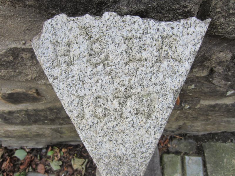
A carved grey granite stone against the southern parapet stands about 0.7m high, and is of triangular cross-section with a sloping top. It bears the inscription ‘BP.A.H.B.’ (for Bishop Auckland Health or Highways Board) on its eastern face, ‘BP.A.L.B.’ (Bishop Auckland Local Board) on its western face, and ‘H&LA | 1878’ (the Highways & Locomotives Amendment) Act of 1878) on its sloping top.
Gaunless Bridge is thought to occupy a crossing point of some antiquity; the route across the River Gaunless was one that would have been taken by the bishops of Durham when travelling between the Cathedral and their palace at Auckland Castle, and Saxton’s map also suggests the Gib Chare crossing was bridged by 1576. However, the first indisputable evidence for a bridge at this location is the mid-C18 when it appears on a series of early large-scale maps of the town.
Adverts were placed for the construction of the present structure in 1762 by the Bowes and Sunderland Bridge Trust, constituted by Act of Parliament in 1747. The bridge was constructed the same year and was about 4.48m (14 ½ feet) wide, and carried a major route in and out of Bishop Auckland.
In 1822 the bridge was extended by 3.52m (about 11 ½ ft) towards the north, downstream side, for the Durham Justices of the Peace. The bridge is shown at its present 8m overall width on the Ordnance Survey (OS) 1:500-scale town map of 1856. It is likely that this widening was designed by Ignatius Bonomi who held the post of Durham County Surveyor of Bridges from 1813 to 1850.
The name ‘Gaunless Bridge’ appears on the 1856 map and all subsequent editions of OS mapping. A gas lamp stand, and a local Board of Health marker stone were added subsequently, the latter in about 1880 after the 1878 Highways Act obliged Local/Highway Boards to take on responsibility for the maintenance of certain bridges.
The bridge was effectively bypassed in 1926 when a new crossing of the river opened a few metres downstream; it is today (2022) used by local traffic only.
Gaunless Bridge of 1762, widened in 1822, is listed at Grade II for the following principal reasons:
Architectural interest:
* a single segmental-arched road bridge that is well-constructed using local materials and incorporates good C18 detailing;
* it dates to the mid-C18 and therefore falls within the period when most bridges are considered to be of special interest;
* its widening in 1822, thought to be by Ignatius Bonomi, Durham County Surveyor of Bridges, was undertaken sympathetically and is clearly legible in the fabric of the structure.
External links are from the relevant listing authority and, where applicable, Wikidata. Wikidata IDs may be related buildings as well as this specific building. If you want to add or update a link, you will need to do so by editing the Wikidata entry.


Other nearby listed buildings
