Approximate Location Map
Large Map »
Latitude: 53.5687 / 53°34'7"N
Longitude: -2.8835 / 2°53'0"W
OS Eastings: 341586
OS Northings: 408374
OS Grid: SD415083
Mapcode National: GBR 8W95.JF
Mapcode Global: WH86H.PK3J
Plus Code: 9C5VH498+FJ
Entry Name: Magistrates Courts
Listing Date: 11 August 1972
Grade: II
Source: Historic England
Source ID: 1197060
English Heritage Legacy ID: 386389
ID on this website: 101197060
Location: Ormskirk, West Lancashire, L39
County: Lancashire
District: West Lancashire
Electoral Ward/Division: Scott
Parish: Non Civil Parish
Built-Up Area: Ormskirk
Traditional County: Lancashire
Lieutenancy Area (Ceremonial County): Lancashire
Church of England Parish: Ormskirk St Peter and St Paul
Church of England Diocese: Liverpool
Tagged with: Architectural structure
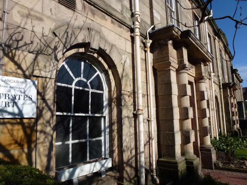
ORMSKIRK
SD4108SE DERBY STREET
663-1/8/152 (North side)
11/08/72 No.7
Magistrates Courts
GV II
Police Station and Magistrates courts, now all courts. 1850,
altered. Sandstone ashlar, and rock faced sandstone at the
side, (roof concealed but probably slate). Large rectangular
plan (plus various C20 additions to rear). Two storeys and 6
bays, symmetrical, the 2nd and 5th bays breaking forwards
slightly, with shallow pediments; with plinth, string course,
moulded cornice and blocking course. The 2nd and 5th bays have
doorways (the latter altered as a window) with doorcases of
heavy banded columns and pilasters, and entablatures with
prominent cornices, the frieze of that to the 2nd bay
inscribed "MAGISTRATES". Otherwise, the ground floor has
round-headed sashed windows with radiating glazing bars, and
the 1st floor has tall 12-pane sashes with moulded
architraves. Stone chimney to left, brick chimneys in centre
and to right. The long left return wall has (inter alia) a
blocked former doorway near the front with lintel inscribed
"CONSTABLE", a cast-iron standard measure built into the wall
near this, and 3 round-headed windows at 1st floor.
Listing NGR: SD4158608374
External links are from the relevant listing authority and, where applicable, Wikidata. Wikidata IDs may be related buildings as well as this specific building. If you want to add or update a link, you will need to do so by editing the Wikidata entry.


Other nearby listed buildings
