Approximate Location Map
Large Map »
Latitude: 54.8925 / 54°53'33"N
Longitude: -2.936 / 2°56'9"W
OS Eastings: 340062
OS Northings: 555712
OS Grid: NY400557
Mapcode National: GBR 7CYV.5Y
Mapcode Global: WH802.W924
Plus Code: 9C6VV3V7+2J
Entry Name: Section of medieval city wall
Listing Date: 11 April 1994
Last Amended: 6 July 2023
Grade: II
Source: Historic England
Source ID: 1197141
English Heritage Legacy ID: 386890
ID on this website: 101197141
Location: Carlisle, Cumberland, Cumbria, CA3
County: Cumbria
District: Carlisle
Parish: Non Civil Parish
Built-Up Area: Carlisle
Traditional County: Cumberland
Lieutenancy Area (Ceremonial County): Cumbria
Church of England Parish: Carlisle St Cuthbert with St Mary
Church of England Diocese: Carlisle
Tagged with: Hotel
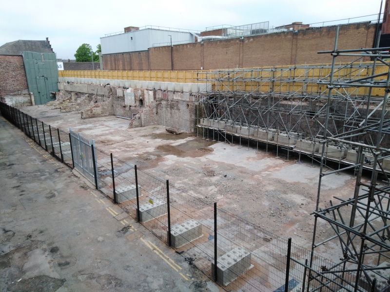
Length of city wall, C12 with later modifications.
City wall, C12 with later modifications.
MATERIALS: sandstone, partially rendered, and underpinned by brick.
PLAN: a 70m linear length of wall.
DESCRIPTION: a length of the medieval town wall of Carlisle, truncated to its upper part, with later modifications. The wall comprises two sections: a longer western part and a shorter eastern part, separated by a set-back.
The western section, which later formed the rear wall of a narrow C19 stable range (now demolished), has rendered upper parts, and the lower walls are formed of thinly-coursed stonework of C19 character thought to be later underpinning. There are the remains of a chamfered plinth above, cut back in places, and above this are three or four courses of large squared sandstone blocks, identified as undisturbed medieval fabric. Various secondary openings pierce the wall including a drain, sockets for floor timbers and a larger hatch with a stone chute below. At the east end of this section the later re-facing extends up to the base of the rendered top section. Five short attached sections of cross walling that originally formed part of the C19 stable range, and which buttress the city wall, are not of special interest and are excluded from the listing.
The section of wall to the east beyond the set back formed the rear of a former late-C19 hotel (now demolished), and medieval masonry is considered to survive in its lower parts; the wall above this, which is of roughly coursed stone incorporating many tooled blocks, is considered to be C19 in date.
Between the Roman and post-medieval periods a number of English towns were provided with defences. These defences served to mark the limits of the town or its intended size and could be used to defend the town in time of trouble. Their symbolic role in marking out the settlement was also significant. Carlisle received defensive stone walls in the C12 by Henry I, which were built from sandstone blocks including some re-used Roman masonry. It is thought that little survives of the north and east sides of the walled circuit but the long south-west facing side, which follows a natural scarp around West Walls, is an almost continuous circuit. Buildings were constructed against part of the walls in the early C19, and joist holes and other features can be seen cut into the wall in places. In the case of this length of wall, a later-C19 hotel and an early-C19 stable range were constructed against it, but were largely demolished in 2020.
This length of stone wall was surveyed in 2022 when it was positively identified as incorporating part of the medieval city wall underpinned by C19 masonry. An archaeological evaluation was undertaken immediately in front of the wall section in order to identify further medieval remains, including a possible medieval town wall ditch. No archaeological features were uncovered earlier than the C19.
This length of medieval city wall with later modifications is listed at Grade II for the following principal reasons:
Architectural Interest:
* an important survival of Carlisle’s medieval city walls, which will also inform us about their evolution into the post-medieval period;
* although modified by later alterations, it retains significant original insitu fabric;
* taken together with adjacent upstanding lengths of designated city walls, it forms an almost complete north-western circuit from the banks of the Caldew to the Citadel.
Historic Interest:
* constructed along with Carlisle Castle by Henry I, the defensive circuit helped to consolidate the Norman hold of Carlisle against numerous Scottish raids and sieges.
External links are from the relevant listing authority and, where applicable, Wikidata. Wikidata IDs may be related buildings as well as this specific building. If you want to add or update a link, you will need to do so by editing the Wikidata entry.


Other nearby listed buildings
