Approximate Location Map
Large Map »
Latitude: 54.8929 / 54°53'34"N
Longitude: -2.9319 / 2°55'54"W
OS Eastings: 340324
OS Northings: 555752
OS Grid: NY403557
Mapcode National: GBR 7CZV.1T
Mapcode Global: WH802.Y80V
Plus Code: 9C6VV3V9+56
Entry Name: 11-29, Warwick Road
Listing Date: 22 March 1974
Last Amended: 11 April 1994
Grade: II
Source: Historic England
Source ID: 1197142
English Heritage Legacy ID: 386891
ID on this website: 101197142
Location: Carlisle, Cumberland, Cumbria, CA1
County: Cumbria
District: Carlisle
Parish: Non Civil Parish
Built-Up Area: Carlisle
Traditional County: Cumberland
Lieutenancy Area (Ceremonial County): Cumbria
Church of England Parish: Carlisle St Cuthbert with St Mary
Church of England Diocese: Carlisle
Tagged with: Building
CARLISLE
NY4055NW WARWICK ROAD
671-1/12/291 (North side)
22/03/74 Nos.11-29 (Odd)
(Formerly Listed as:
WARWICK ROAD
Nos.11-31 (Odd))
GV II
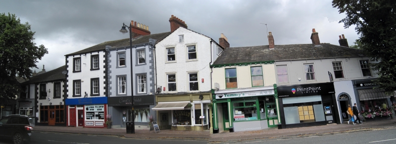
Terrace of public house and 7 houses, now 9 shops, some with
offices above. 1830s with later alterations. Painted stucco
and render, some with V-jointed quoins and stone-bracketed
metal gutters. Graduated greenslate roofs, hipped on corners;
C19 and C20 end and ridge chimney stacks.
Central 3 shops are 3 storeys, 2 bays, rest are 2 storey, 2
bays, each of differing roof lines, but 2-storey buildings
share common roofs. Mixed early C20 and late C20 shop fronts
on each ground floor. Sash windows above, some with glazing
bars in painted stone architraves. No.11 was formerly the Lord
Brougham Inn until closure in 1932 (for illustration see
Perriam (1988)) and has a 7-bay return on Crosby Street. No.29
has a 2-bay return on Earl Street; there is no No.31 which is
mentioned in previous list description.
INTERIORS: No.17, a butcher's shop, has early C20 shop window
and tiled interior; individual tiles at intervals have cattle
scenes and bulls heads; marble slabs; otherwise not inspected.
Street was laid out as turnpike road to Brampton 1829-30 and,
when built, this part of Warwick Road was called Henry Street.
(Perriam DR: Carlisle in Camera: 1988-: P.51).
Listing NGR: NY4032455760
External links are from the relevant listing authority and, where applicable, Wikidata. Wikidata IDs may be related buildings as well as this specific building. If you want to add or update a link, you will need to do so by editing the Wikidata entry.


Other nearby listed buildings
