Approximate Location Map
Large Map »
Latitude: 51.6669 / 51°40'0"N
Longitude: -1.2832 / 1°16'59"W
OS Eastings: 449672
OS Northings: 196697
OS Grid: SU496966
Mapcode National: GBR 7YR.DDD
Mapcode Global: VHCY6.QC0J
Plus Code: 9C3WMP88+PP
Entry Name: Wall to the Old Anchor Inn
Listing Date: 10 December 1971
Grade: II
Source: Historic England
Source ID: 1199819
English Heritage Legacy ID: 250478
ID on this website: 101199819
Location: Abingdon-on-Thames, Vale of White Horse, Oxfordshire, OX14
County: Oxfordshire
District: Vale of White Horse
Civil Parish: Abingdon on Thames
Built-Up Area: Abingdon
Traditional County: Berkshire
Lieutenancy Area (Ceremonial County): Oxfordshire
Church of England Parish: Abingdon-on-Thames
Church of England Diocese: Oxford
Tagged with: Wall
1.
752 ST HELEN'S WHARF
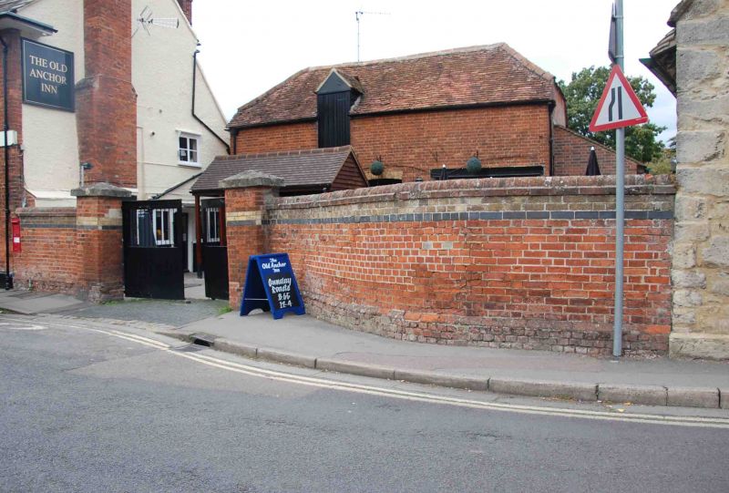
SU 4996 1/206A Wall to the Old Anchor Inn
II
2.
Red brick, plinth. Two piers, pyramided stone caps. Banded with yellow
and blue brick.
Listing NGR: SU4967296697
External links are from the relevant listing authority and, where applicable, Wikidata. Wikidata IDs may be related buildings as well as this specific building. If you want to add or update a link, you will need to do so by editing the Wikidata entry.


Other nearby listed buildings
