Approximate Location Map
Large Map »
Latitude: 51.3876 / 51°23'15"N
Longitude: 1.3806 / 1°22'50"E
OS Eastings: 635303
OS Northings: 170814
OS Grid: TR353708
Mapcode National: GBR WZS.V64
Mapcode Global: VHLG6.WD64
Plus Code: 9F3399QJ+26
Entry Name: 80, High Street
Listing Date: 22 February 1973
Grade: II
Source: Historic England
Source ID: 1203718
English Heritage Legacy ID: 356589
ID on this website: 101203718
Location: Margate, Thanet, Kent, CT9
County: Kent
District: Thanet
Electoral Ward/Division: Margate Central
Parish: Non Civil Parish
Built-Up Area: Margate
Traditional County: Kent
Lieutenancy Area (Ceremonial County): Kent
Tagged with: Building
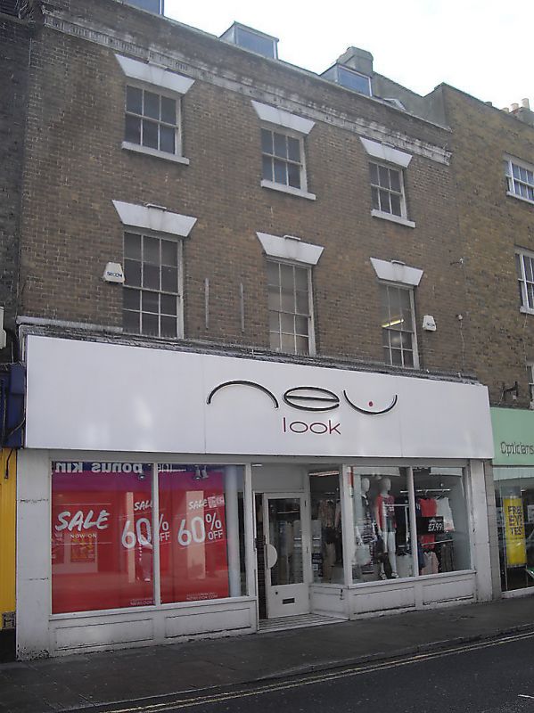
HIGH STREET
1.
1380
(West Side)
No 80
TR 3570 NW 1/199
II GV
2.
Early C19. 3 storeys brick. Slate roof with 3 dormers. Dropped moulded
eaves cornice with reeded band. 3 sashes with glazing bars intact and
stringcourses. Stone heads with keystones and stone cills. Modern shopfront.
Nos 72 and Nos 76 to 82 (even) form a group
Listing NGR: TR3530370814
External links are from the relevant listing authority and, where applicable, Wikidata. Wikidata IDs may be related buildings as well as this specific building. If you want to add or update a link, you will need to do so by editing the Wikidata entry.


Other nearby listed buildings
