Approximate Location Map
Large Map »
Latitude: 51.3883 / 51°23'17"N
Longitude: 1.3818 / 1°22'54"E
OS Eastings: 635383
OS Northings: 170898
OS Grid: TR353708
Mapcode National: GBR WZS.VJ6
Mapcode Global: VHLG6.WCVL
Plus Code: 9F3399QJ+8P
Entry Name: Sunday School to Right of Baptist Church
Listing Date: 22 February 1973
Grade: II
Source: Historic England
Source ID: 1203940
English Heritage Legacy ID: 356639
ID on this website: 101203940
Location: Margate, Thanet, Kent, CT9
County: Kent
District: Thanet
Electoral Ward/Division: Margate Central
Parish: Non Civil Parish
Built-Up Area: Margate
Traditional County: Kent
Lieutenancy Area (Ceremonial County): Kent
Tagged with: Sunday school
NEW STREET
1.
1380
(South Side)
Sunday School
to right of
Baptist Church
TR 3570 NW 1/260
II GV
2.
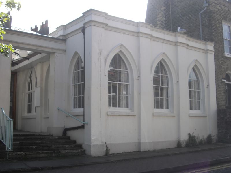
Circa 1870, in matching style to the Baptist Church. 1 storey stuccoed.
Hipped slate roof. Eaves cornice. 3 pointed lights in the front elevation
and a double doorcase set in a pointed archway.
Cecil Square Baptist Church, Sunday School and Nos 8 to 10 (consec)
form a group
Listing NGR: TR3538370898
External links are from the relevant listing authority and, where applicable, Wikidata. Wikidata IDs may be related buildings as well as this specific building. If you want to add or update a link, you will need to do so by editing the Wikidata entry.


Other nearby listed buildings
