Approximate Location Map
Large Map »
Latitude: 51.4602 / 51°27'36"N
Longitude: -2.5885 / 2°35'18"W
OS Eastings: 359207
OS Northings: 173637
OS Grid: ST592736
Mapcode National: GBR C9H.JD
Mapcode Global: VH88N.2KWF
Plus Code: 9C3VFC66+3H
Entry Name: Numbers 14, 15 and 16 and Attached Area Railings
Listing Date: 8 January 1959
Last Amended: 30 December 1994
Grade: II
Source: Historic England
Source ID: 1204541
English Heritage Legacy ID: 379030
ID on this website: 101204541
Location: Kingsdown, Bristol, BS2
County: City of Bristol
Electoral Ward/Division: Central
Parish: Non Civil Parish
Built-Up Area: Bristol
Traditional County: Gloucestershire
Lieutenancy Area (Ceremonial County): Bristol
Church of England Parish: Bristol St Paul's
Church of England Diocese: Bristol
Tagged with: Building
BRISTOL
ST5973NW BRUNSWICK SQUARE, St Paul
901-1/6/1881 (West side)
08/01/59 Nos.14, 15 AND 16
and attached area railings
(Formerly Listed as:
BRUNSWICK SQUARE
(West side)
Nos.14-16 (Consecutive))
GV II
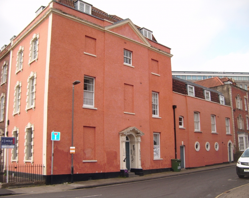
Terrace of 3 houses. 1766-1771. By Thomas Paty. Brick with
limestone dressings, brick stacks and a pantile mansard roof.
3 storeys, basement and attic; 3-windows each, 2 to No.16. Mid
Georgian style.
Articulated by pilasters, cornice and parapet; right-hand
pedimented doorcases have Gibbs surrounds and raised keyed
entablatures, and 4-panel doors with rectangular overlights;
Gibbs suround to windows with keys to 6/6-pane sashes, smaller
on the second floor, and 2 dormers. Entrance to No.16 in
Cumberland Road has attached Doric columns to a modillion
pediment and plate-glass fanlight, set in a symmetrical
pedimented elevation; to the right is a 2-storey ancillary
block with round ground-floor windows.
INTERIOR: No.14, central lateral dogleg stair, fluted
pilasters to segmental arches to the ground-floor rooms,
modillion cornices and panelled shutters.
SUBSIDIARY FEATURES: cast-iron railings to areas.
The W side of the square is different from the designs of the
S and E; the rest of the terrace was never completed.
(Gomme A, Jenner M and Little B: Bristol, An Architectural
History: Bristol: 1979-: 207; Dening C F W: The Eighteenth
Century Architecture of Bristol: Bristol: 1923-: 53).
Listing NGR: ST5920773637
External links are from the relevant listing authority and, where applicable, Wikidata. Wikidata IDs may be related buildings as well as this specific building. If you want to add or update a link, you will need to do so by editing the Wikidata entry.


Other nearby listed buildings
