Approximate Location Map
Large Map »
Latitude: 54.1262 / 54°7'34"N
Longitude: -3.2258 / 3°13'32"W
OS Eastings: 319990
OS Northings: 470734
OS Grid: SD199707
Mapcode National: GBR 5NXQ.FM
Mapcode Global: WH72H.FK44
Plus Code: 9C6R4QGF+FM
Entry Name: Borough Cemetery Gate House and Attached Railings
Listing Date: 20 December 1993
Grade: II
Source: Historic England
Source ID: 1209811
English Heritage Legacy ID: 388437
ID on this website: 101209811
Location: Ormsgill, Westmorland and Furness, Cumbria, LA14
County: Cumbria
District: Barrow-in-Furness
Electoral Ward/Division: Ormsgill
Parish: Non Civil Parish
Built-Up Area: Barrow-in-Furness
Traditional County: Lancashire
Lieutenancy Area (Ceremonial County): Cumbria
Church of England Parish: Barrow-in-Furness St Matthew
Church of England Diocese: Carlisle
Tagged with: Architectural structure
BARROW IN FURNESS
SD17SE DEVONSHIRE ROAD
708-1/3/41 (North side)
Borough Cemetery gatehouse and
attached railings
II
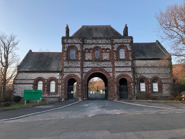
Cemetery gatehouse with attached railings. Dated 1874. By
Paley and Austin (plan), altered. Coursed limestone with red
sandstone dressings, graduated slate roof.
2-storey, 3-bay centre with 1-storey, 2-window office in side
wing on left and 2-storey lodge on right of same width but
with wing to rear; attached railings are set in quadrants to
each side and return to line pavement.
Romanesque. Chamfered plinth, quoins. Tall central carriage
arch recessed between pedestrian side gates: each opening has
keeled arches of 2 orders linked by impost string course;
original iron gates. 2 bands and 1st floor sill band beneath
blind arcading with taller central window; outer bays have
larger windows in 2-order arches. Band beneath parapet with
triangular copings built up in 2 courses.
Hipped roof with a multiple-flue ashlar stack to each end;
terracotta ridge cresting. Office wing on left: buttress
against left return; paired windows with colonnettes and
impost string course; coped end gable. Lodge on right: similar
but taller, no 1st floor windows to front.
Rear: 2 dated rain-water heads; office has shallow, canted
bay-window. Ribbed vaulting within the archway, 2-bay arcades
and barrel vaults to each side. Railings: panels are fixed
between sandstone piers rising from dwarf walls; the railings
have square bars, twin top rails and finials of 2 heights.
Surviving drawings dated November 1873 show a central bell
tower with spire; this and some other architectural details
(shafts, mouldings) have since been removed.
(Building Plans Register: 1873-: NO.520).
Listing NGR: SD1999070734
External links are from the relevant listing authority and, where applicable, Wikidata. Wikidata IDs may be related buildings as well as this specific building. If you want to add or update a link, you will need to do so by editing the Wikidata entry.


Other nearby listed buildings
